1940s Maps of Daddys Creek, Tennessee
Explore 2 historic maps of Daddys Creek from the 1940s. These maps offer a rare glimpse into what life looked like during the 1940s — showing old roads, neighborhoods, homes, and landmarks that have changed or disappeared over time.
Whether you're researching your family's past, planning a metal detecting trip, or studying how Daddys Creek's landscape evolved across the 1940s, these high-resolution maps are a powerful tool for exploring the history of this region.
- Focus on a specific era: All maps on this page are from the 1940s, giving you a focused view of this time period.
- See what’s changed: Compare century-old streets, trails, and buildings to today's modern landscape using overlays and satellite layers.
- Research with precision: Use these maps for genealogy, historical research, land use analysis, or educational projects.
- View, download, or print: Maps are fully viewable online in high resolution, and can be downloaded or printed for your own records.
Start exploring Daddys Creek's history through authentic maps from the 1940s. This is your window into the past.
Daddys Creek, TN maps
(2)- 1946 Map of Dorton, 1971 Print
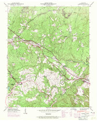 1946 Dorton1971 Print · USGSCumberland County during the post-war era showcases the fascinating New Deal planning of the Cumberland Homesteads. Genealogists and historians can trace family locations near the Homestead Cem, Baker Chapel, and the tracks of the Tennessee Central railroad.2 unique versions available
 - 1949 Map of Dorton
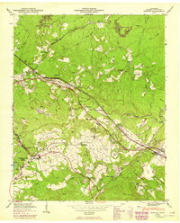 1949 Dorton1949 Print · USGSCumberland County’s plateau landscape is captured here in the mid-century during the development of the Tennessee Central Railroad. Researchers can locate family sites at Turner Cem and Homestead Cem, or trace early community hubs like Dorton Sch and Baker Chapel.2 unique versions available
End of results
Showing maps 1-2 of 2
Top cities near Daddys Creek
- Crossville historical maps
- Fairfield Glade historical maps
- Rockwood historical maps
- Spring City historical maps
- Crab Orchard historical maps
Frequently asked questions
- What are the different types of historical maps available for Daddys Creek?
- What is the oldest map of Daddys Creek?
- Where can I purchase historical maps of Daddys Creek for my home or office?
- Where can I download high-res historical maps of Daddys Creek?
- Are there historical topographic maps available for Daddys Creek?
- Is there historical aerial imagery available for Daddys Creek?
- Where are historical maps of Daddys Creek sourced from?