Old Maps of Mayland, Tennessee for Genealogy
Trace your family roots with 13 historic maps of Mayland. These high-res maps reveal old neighborhoods, homesites, landmarks, and streets — helping you uncover where your ancestors lived and how the area evolved over time.
- Explore historic neighborhoods: Identify where your relatives may have lived in the 1800s or 1900s.
- Compare maps over time: Trace the changes in streets, buildings, and landmarks for multi-generational research.
- Perfect for genealogy & ancestry research: Used by family historians and researchers to map out lineage and migration.
These maps are an incredible resource for exploring your personal connection to Mayland's past.
Mayland, TN maps
(13)- 1897 Map of Standingstone
 1897 Standingstone1897 Print · USGSThe Upper Cumberland Plateau at the end of the 19th century shows a landscape of deep coves and rising rail towns. Trace the early tracks of the Nashville and Knoxville railroad or find family roots near Livingston, Standingstone, and the Cedar Springs church.
 - 1898 Map of Standingstone
 1898 Standingstone1898 Print · USGSThe Cumberland Plateau of Middle Tennessee comes alive in the late nineteenth century, showing the isolated settlements and early industry of the western mountains. Trace the route of the Nashville and Knoxville RR through Monterey or locate family-named coves like Johnson Cove and Deck Cove.8 unique versions available
 - 1935 Map of Campbell Junction
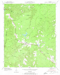
 1935 Campbell Junction1935 Print · USGSCumberland County’s high plateau country is documented here in the mid-1930s as modern power and transit networks begin to cross the landscape. Researchers can trace the early path of Tennessee State Highway No 70 and the railroad at Campbell Junction.
 - 1946 Map of Campbell Junction, 1974 Print
 1946 Campbell Junction1974 Print · USGSThe high Cumberland Plateau comes into focus in the mid-1940s as the Tennessee Central railroad links small upland communities. Genealogists and local researchers can trace family sites at Welch Cem, Rains Cem, and Pugh Cem or locate the early grounds of Camp Nakanawa.3 unique versions available
 - 1950 Map of Campbell Junction
 1950 Campbell Junction1950 Print · USGSThe Cumberland Plateau in the mid-century is captured here as the Tennessee Central railroad snakes through the divide between Putnam and Cumberland counties. Family researchers can trace local roots through Welch Cem, Rains Cem, and settlements like Campbell Junction and The Cowpens.2 unique versions available
 - 1956 Map of Corbin, 1966 Print
 1956 Corbin1966 Print · USGSThe Kentucky and Tennessee borderlands are captured here in the mid-fifties, showing the region's shift toward modern interstate travel and reservoir development. Genealogists and historians can trace old community lines near Albany and Monticello or locate early rail junctions along the Southern and Tennessee Central lines.3 unique versions available
 - 1958 Map of Corbin
 1958 Corbin1958 Print · USGSThe Upper Cumberland borderlands appear in the late 1950s as massive reservoirs and early atomic-era growth reshape the region. Trace family roots and vanished landmarks near Lake Cumberland, Oak Ridge, and the Cumberland National Forest.
 - 1982 Map of Cookeville, 1983 Print
 1982 Cookeville1983 Print · USGSThe Upper Cumberland region comes into focus during the early eighties as Cookeville and its surrounding counties adapt to new reservoirs and highways. Researchers can trace the Louisville and Nashville rail line and locate landmarks like Tennessee Technological University and Standing Stone State Forest.
 - 2010 Map of Campbell Junction, 2010 Print
 2010 Campbell Junction2010 Print · USGSCovers Mayland, including Monterey, Hillwood Estates, and other nearby areas
 - 2013 Map of Campbell Junction, 2013 Print
 2013 Campbell Junction2013 Print · USGSCovers Mayland, including Monterey, Hillwood Estates, and other nearby areas
 - 2016 Map of Campbell Junction, 2016 Print
 2016 Campbell Junction2016 Print · USGSCovers Mayland, including Monterey, Hillwood Estates, and other nearby areas
 - 2019 Map of Campbell Junction, 2019 Print
 2019 Campbell Junction2019 Print · USGSCovers Mayland, including Monterey, Hillwood Estates, and other nearby areas
 - 2022 Map of Campbell Junction, 2022 Print
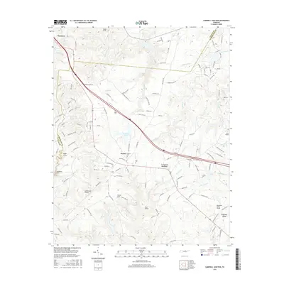
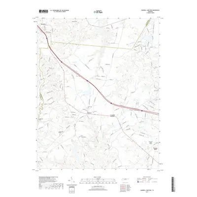
 2022 Campbell Junction2022 Print · USGSCumberland County at the headwaters of the Caney Fork reveals a landscape of high plateau ridges and deep hollows. Researchers can trace family roots through several local burial grounds including Welch Cem, Mayland Cem, and the high ground of Stillhouse Rock.
End of results
Showing maps 1-13 of 13
Top cities near Mayland
- Crossville historical maps
- Algood historical maps
- Monterey historical maps
- Pleasant Hill historical maps
Frequently asked questions
- What are the different types of historical maps available for Mayland?
- What is the oldest map of Mayland?
- Where can I purchase historical maps of Mayland for my home or office?
- Where can I download high-res historical maps of Mayland?
- Are there historical topographic maps available for Mayland?
- Is there historical aerial imagery available for Mayland?
- Where are historical maps of Mayland sourced from?