1990s Maps of Davidson County, Tennessee
Explore 11 historic maps of Davidson County from the 1990s. These maps offer a rare glimpse into what life looked like during the 1990s — showing old roads, neighborhoods, homes, and landmarks that have changed or disappeared over time.
Whether you're researching your family's past, planning a metal detecting trip, or studying how Davidson County's landscape evolved across the 1990s, these high-resolution maps are a powerful tool for exploring the history of this region.
- Focus on a specific era: All maps on this page are from the 1990s, giving you a focused view of this time period.
- See what’s changed: Compare century-old streets, trails, and buildings to today's modern landscape using overlays and satellite layers.
- Research with precision: Use these maps for genealogy, historical research, land use analysis, or educational projects.
- View, download, or print: Maps are fully viewable online in high resolution, and can be downloaded or printed for your own records.
Start exploring Davidson County's history through authentic maps from the 1990s. This is your window into the past.
Davidson County, TN maps
(11)- 1994 Map of Whites Creek, 1997 Print
 1994 Whites Creek1997 Print · USGSNorth of Nashville in the mid-1990s, the hollows and ridges of the Highland Rim remained a patchwork of small communities and family landmarks. Genealogists and local historians can trace the foundations of Joelton and Whites Creek or locate historic sites like Walkers Ch and Alex Green Sch.
 - 1994 Map of Forest Grove, 1997 Print
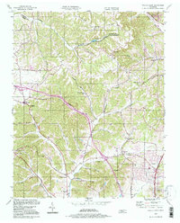
 1994 Forest Grove1997 Print · USGSThe hills of Cheatham and Davidson Counties are captured here in the mid-nineties, showing a landscape of rural ridges and developing communities. Researchers can trace the heritage of local settlements through landmarks like Paines Chapel, Morny Sch, and the winding Old Clarksville Pike.
 - 1997 Map of Nashville West, 1999 Print
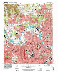 1997 Nashville West1999 Print · USGSNashville and the Cumberland River are shown in the late 1990s, capturing the city's academic core and expanding industrial infrastructure. Researchers can trace historic sites like Fisk University, the City Cem, and the State Penitentiary during a period of significant urban change.
 - 1997 Map of Hermitage, 2001 Print
 1997 Hermitage2001 Print · USGSThe suburbs east of Nashville were rapidly evolving in the late nineties as legacy estates met modern reservoirs. Genealogists and historians can trace the grounds of The Hermitage, locate the Mount Juliet Cem, and explore the shoreline of Old Hickory Lake.
 - 1997 Map of Nashville East, 2002 Print
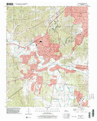
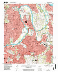 1997 Nashville East2002 Print · USGSEast Nashville and the winding Cumberland River are captured here in the late nineties as suburban growth reached toward Old Hickory Lake. Researchers can trace family roots at Mount Olivet Cemetery or locate local landmarks like Cornelia Fort Airpark and Donelson.
 - 1997 Map of La Vergne, 2002 Print
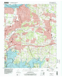
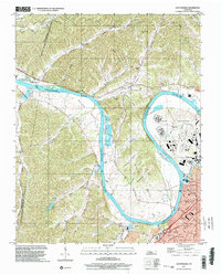
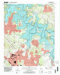 1997 La Vergne2002 Print · USGSThe Rutherford and Davidson County line near La Vergne underwent significant change in the late twentieth century as the Stones River valley was transformed by a massive reservoir. Researchers can trace the footprint of older communities like Couchville and Savage alongside more modern developments like the Smyrna Airport and Hamilton Creek Park.
 - 1997 Map of Oak Hill, 2002 Print
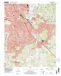
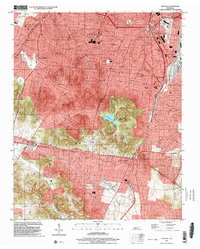 1997 Oak Hill2002 Print · USGSSouth of Nashville in the late nineties, these residential enclaves expanded toward the Williamson County line. Researchers can trace the development of Belle Meade and Oak Hill, or locate local landmarks like Radnor Lake and the Governors Mansion.
 - 1997 Map of Scottsboro, 2002 Print
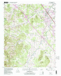
 1997 Scottsboro2002 Print · USGSDavidson County in the late nineties is defined by the winding Cumberland River and the expanding suburbs of Nashville. Researchers can locate the State Penitentiary grounds, family burial sites at Bull Run Cems, and local landmarks like Watkins Chapel.
 - 1997 Map of Bellevue, 2002 Print
 1997 Bellevue2002 Print · USGSGreater Nashville was rapidly expanding toward the Harpeth River valley in the late nineties, blending suburban growth with older river-bend settlements. Trace local landmarks like the Bellevue High Sch, Warner Park, and the winding Harpeth River.
 - 1998 Map of Smyrna, 1999 Print
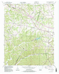
 1998 Smyrna1999 Print · USGSRutherford and Davidson counties are mapped here in the late nineties as regional growth begins to reshape the landscape. Genealogists and researchers can trace local family lineages through numerous small burial sites like Dewitt Smith Jobe Cem, Sanford Cem, and the Sam Davis Home Cem.
 - 1999 Map of Antioch, 2002 Print
 1999 Antioch2002 Print · USGSThe Antioch and south Nashville area comes into focus at the end of the millennium as suburban development spreads toward the Williamson County line. Trace family landmarks and community anchors from Whittset Cem to schools like Binkley Sch and Turner Sch.
End of results
Showing maps 1-11 of 11
Top cities of Davidson County
- Nashville historical maps
- Forest Hills historical maps
- Oak Hill historical maps
- Belle Meade historical maps
- Berry Hill historical maps
Frequently asked questions
- What are the different types of historical maps available for Davidson County?
- What is the oldest map of Davidson County?
- Where can I purchase historical maps of Davidson County for my home or office?
- Where can I download high-res historical maps of Davidson County?
- Are there historical topographic maps available for Davidson County?
- Is there historical aerial imagery available for Davidson County?
- Where are historical maps of Davidson County sourced from?