1960s Maps of Davidson County, Tennessee
Explore 14 historic maps of Davidson County from the 1960s. These maps offer a rare glimpse into what life looked like during the 1960s — showing old roads, neighborhoods, homes, and landmarks that have changed or disappeared over time.
Whether you're researching your family's past, planning a metal detecting trip, or studying how Davidson County's landscape evolved across the 1960s, these high-resolution maps are a powerful tool for exploring the history of this region.
- Focus on a specific era: All maps on this page are from the 1960s, giving you a focused view of this time period.
- See what’s changed: Compare century-old streets, trails, and buildings to today's modern landscape using overlays and satellite layers.
- Research with precision: Use these maps for genealogy, historical research, land use analysis, or educational projects.
- View, download, or print: Maps are fully viewable online in high resolution, and can be downloaded or printed for your own records.
Start exploring Davidson County's history through authentic maps from the 1960s. This is your window into the past.
Davidson County, TN maps
(14)- 1961 Map of Greenbrier, 1963 Print
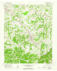 1961 Greenbrier1963 Print · USGSRobertson County's rail-and-road corridor comes alive in the early sixties as communities grew along the Louisville and Nashville line. Genealogists can trace family landmarks like the Bloodworth Cem, Lights Chapel Cem, and Hygeia Springs.3 unique versions available
 - 1961 Map of Springfield South, 1963 Print
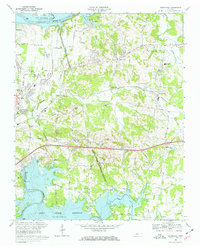
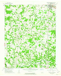 1961 Springfield South1963 Print · USGSRobertson County's rural landscapes and agricultural crossroads are captured here in the early sixties. Researchers can locate family landmarks like Martins Chapel Cem, the County Farm, and community hubs like Glover Crossroad.4 unique versions available
 - 1966 Map of Kingston Springs, 1967 Print
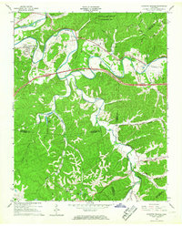 1966 Kingston Springs1967 Print · USGSIn the mid-sixties, the Harpeth River valley near Kingston Springs maintained its rural character and winding rail lines. Genealogists and local historians can locate several country churches like Wards Chapel and Lone Oak Ch, or trace the path of the Louisville and Nashville railroad.4 unique versions available
 - 1966 Map of Lillamay, 1967 Print
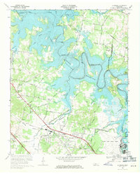
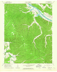 1966 Lillamay1967 Print · USGSThe Harpeth and Cumberland rivers frame this 1960s landscape of managed wilds and ancient sites. Genealogists and historians can trace Indian Mounds at Mound Bottom and local landmarks like Sams Creek Ch and Scott Cem.3 unique versions available
 - 1968 Map of Oak Hill
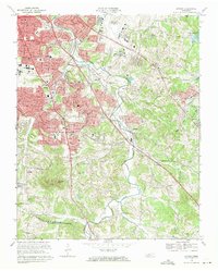
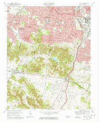 1968 Oak Hill1968 Print · USGSThe affluent suburbs and rugged ridges south of Nashville are captured here in the late sixties as residential growth moved toward the Williamson County line. Researchers can locate long-standing institutions like Harpeth Hall Sch, the Vanderbilt University Observatory, and historical routes like Granny White Pike.5 unique versions available
 - 1968 Map of Scottsboro, 1970 Print
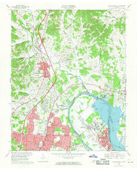
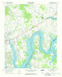
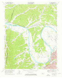 1968 Scottsboro1970 Print · USGSThe Cumberland River loops west of Nashville in the late sixties as suburban growth meets the rural bends. Trace the river economy via Cleeces Ferry and the Illinois Central Railroad, or find the massive State Penitentiary at Cockrill Bend.4 unique versions available
 - 1968 Map of Hermitage, 1970 Print
 1968 Hermitage1970 Print · USGSThe Hermitage area in the late sixties displays a landscape transitioning from rural estates to suburban reaches between two major Tennessee reservoirs. Trace local history through The Hermitage Tomb, Mount Juliet High Sch, and family-named landmarks like Bakers Grove Ch.3 unique versions available
 - 1968 Map of Nashville West, 1971 Print
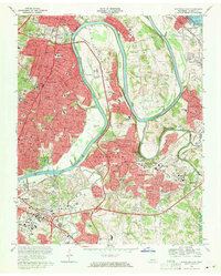
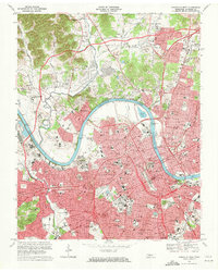 1968 Nashville West1971 Print · USGSNashville was undergoing rapid urban transformation in the late sixties as the interstate system carved through its historic districts. Researchers can trace the mid-century city layout of Fisk University, the State Capitol, and the Tennessee Central RR lines.4 unique versions available
 - 1968 Map of La Vergne, 1971 Print
 1968 La Vergne1971 Print · USGSIn the late 1960s, the Stones River valley transformed as the J Percy Priest Reservoir rose to its normal pool elevation. Genealogists and local historians can trace the foundations of La Vergne and identify rural landmarks like Burnette Chapel and the Sewart Air Force Base.3 unique versions available
 - 1968 Map of Antioch, 1971 Print
 1968 Antioch1971 Print · USGSSoutheast Nashville and the Antioch area are captured here during a period of rapid mid-century growth as suburban neighborhoods began to climb the local ridges. Researchers can locate several family cemeteries and historic landmarks like Central State Hospital, Whitsett Cem, and the Antioch settlement.4 unique versions available
 - 1968 Map of Goodlettsville, 1971 Print
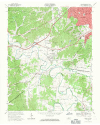
 1968 Goodlettsville1971 Print · USGSThe northern suburbs of Nashville were rapidly evolving in the late sixties as the Cumberland River landscape was reshaped. Researchers can find many family landmarks, from Lutons Chapel and Old Center Ch to the rail siding at Amqui.4 unique versions available
 - 1968 Map of Nashville East, 1971 Print
 1968 Nashville East1971 Print · USGSEast Nashville and the winding Cumberland River meanders are captured here during the peak of late-sixties suburban development. Genealogists and researchers can trace family landmarks like Spring Hill Cemetery, Clover Bottom, and Donelson.5 unique versions available
 - 1968 Map of Bellevue, 1971 Print
 1968 Bellevue1971 Print · USGSNashville's southwestern suburbs meet the winding Harpeth River valley during a period of mid-century growth. Researchers can trace the development of West Meade and Bellevue alongside historic sites like Morton Mill and Gower Sch.4 unique versions available
 - 1968 Map of Hendersonville, 1971 Print
 1968 Hendersonville1971 Print · USGSThe Hendersonville area is captured here during its late-sixties growth as Old Hickory Lake reshaped the local topography. Genealogists can trace family roots through landmarks like St Johns Ch, Peytona, and the rural schools and churches of Shackle Island.2 unique versions available
End of results
Showing maps 1-14 of 14
Top cities of Davidson County
- Nashville historical maps
- Forest Hills historical maps
- Oak Hill historical maps
- Belle Meade historical maps
- Berry Hill historical maps
Frequently asked questions
- What are the different types of historical maps available for Davidson County?
- What is the oldest map of Davidson County?
- Where can I purchase historical maps of Davidson County for my home or office?
- Where can I download high-res historical maps of Davidson County?
- Are there historical topographic maps available for Davidson County?
- Is there historical aerial imagery available for Davidson County?
- Where are historical maps of Davidson County sourced from?