1930s Maps of Parsons, Tennessee
Explore 3 historic maps of Parsons from the 1930s. These maps offer a rare glimpse into what life looked like during the 1930s — showing old roads, neighborhoods, homes, and landmarks that have changed or disappeared over time.
Whether you're researching your family's past, planning a metal detecting trip, or studying how Parsons's landscape evolved across the 1930s, these high-resolution maps are a powerful tool for exploring the history of this region.
- Focus on a specific era: All maps on this page are from the 1930s, giving you a focused view of this time period.
- See what’s changed: Compare century-old streets, trails, and buildings to today's modern landscape using overlays and satellite layers.
- Research with precision: Use these maps for genealogy, historical research, land use analysis, or educational projects.
- View, download, or print: Maps are fully viewable online in high resolution, and can be downloaded or printed for your own records.
Start exploring Parsons's history through authentic maps from the 1930s. This is your window into the past.
Parsons, TN maps
(3)- 1936 Map of Parsons
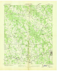 1936 Parsons1936 Print · USGSDecatur and Henderson counties are captured here in the mid-1930s, showing a landscape defined by the Nashville Chattanooga and St Louis Railway. Trace family history across rural settlements and landmarks like Old Safford, Wilkinstown, and the Cedar Hill Ch & Cem.
 - 1936 Map of Jeannette
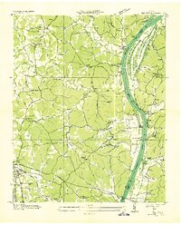 1936 Jeannette1936 Print · USGSDecatur County's riverbank communities and hills are captured here in the mid-thirties as the Tennessee River valley underwent significant change. Genealogists and historians can locate family landmarks like Walker Cem and trace the paths to Busseltown or Bells Store.
 - 1936 Map of Perryville
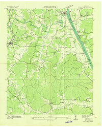 1936 Perryville1936 Print · USGSDecatur County at the height of the Great Depression shows a river-dependent landscape centered on the Tennessee River. Researchers can locate several river landings and crossings, including Perryville Ferry and Mt Zion Cem.
End of results
Showing maps 1-3 of 3
Top cities near Parsons
Top neighborhoods of Parsons
Frequently asked questions
- What are the different types of historical maps available for Parsons?
- What is the oldest map of Parsons?
- Where can I purchase historical maps of Parsons for my home or office?
- Where can I download high-res historical maps of Parsons?
- Are there historical topographic maps available for Parsons?
- Is there historical aerial imagery available for Parsons?
- Where are historical maps of Parsons sourced from?