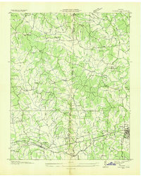
1936 Map of Parsons
USGS Topo · Published 1936About this map
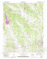
The Nashville Chattanooga and St Louis Railway carves through the southern landscape of this 1936 survey, anchoring the growth of Parsons and Darden. This Tennessee Valley Authority collaboration reveals a rural society structured around decentralized community hubs like Old Safford, New Safford, and Bible Hill, each defined by their local institutions. The terrain is a dense network of creek drainages, including Sulphur Creek and Cub Creek, which dictated the placement of numerous family-named landmarks and country schools such as Moore Hill Sch and Pleasant Hill Sch.
Find a feature on this map
57 named features on this map. Tap any name to fly to it.
Don’t see what you’re looking for? This feature index may not catch every label — zoom into the map to look around manually.
Map Details
Editions of this 1936 Parsons Map
This is the sole edition of this map. No revisions or reprints were ever made.
Historical Maps of Parsons Through Time
7 maps found