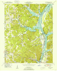
1949 Map of Jeannette
USGS Topo · Published 1953About this map
The Tennessee River corridor in Decatur County is dominated by the vast impoundment of Kentucky Lake, reflecting the transformative post-war river engineering of the era. The shoreline is marked by the Busseltown Dewatering Area and the Kentucky National Wildlife Refuge, showcasing how the landscape was adapted for flood control and conservation. Near the southern edge, the town of Parsons serves as a hub, connected to the eastern bank by the Alvin C York Bridge.
Find a feature on this map
82 named features on this map. Tap any name to fly to it.
Don’t see what you’re looking for? This feature index may not catch every label — zoom into the map to look around manually.
Map Details
Editions of this 1949 Jeannette Map
2 editions found
Other maps of this area

1936 · Pine View
USGS Topo · 1:24,000

1936 · Scotts Hill
USGS Topo · 1:24,000

1936 · Parsons
USGS Topo · 1:24,000

1936 · Daniels Landing
USGS Topo · 1:24,000

1936 · Jeannette
USGS Topo · 1:24,000

1936 · Sugar Tree
USGS Topo · 1:24,000

1936 · Cavvia
USGS Topo · 1:24,000

1936 · Perryville
USGS Topo · 1:24,000

1936 · Pope
USGS Topo · 1:24,000

1949 · Perryville
USGS Topo · 1:24,000