
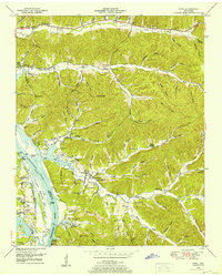
1936 Map of Pine View
USGS Topo · Published 1936About this map
Pine View and its surrounding hollows are meticulously documented in this 1936 field examination, showcasing a rural Tennessee landscape defined by a network of creek branches and ridge trails. The settlement pattern is anchored by local institutions like Dixon Ch and Union Ch, while educational needs were served by small outposts such as Nathan Sch and Spring Creek Sch. The geography is remarkably detailed, naming dozens of minor drainages including Patrey Branch and Sugar Camp Hollow, reflecting the topographical complexity of Sparks Ridge and Bunker Hill. Genealogical researchers will find significant value in the identified family burial grounds, such as Bible Hill Cem and Welms Cem, which are situated along the winding paths of Tom Creek and Lick Creek. This survey captures a moment before modern consolidation, where life revolved around the immediate watercourses and narrow valley floors.
Find a feature on this map
51 named features on this map. Tap any name to fly to it.
Don’t see what you’re looking for? This feature index may not catch every label — zoom into the map to look around manually.
Map Details
Editions of this 1936 Pine View Map
This is the sole edition of this map. No revisions or reprints were ever made.
Other maps of this area

1936 · Daniels Landing
USGS Topo · 1:24,000

1936 · Linden
USGS Topo · 1:24,000

1936 · Chestnut Grove
USGS Topo · 1:24,000

1936 · Jeannette
USGS Topo · 1:24,000

1936 · Sugar Tree
USGS Topo · 1:24,000

1936 · Lobelville
USGS Topo · 1:24,000

1936 · Perryville
USGS Topo · 1:24,000

1936 · Pope
USGS Topo · 1:24,000

1949 · Perryville
USGS Topo · 1:24,000
1949 · Pope
USGS Topo · 1:24,000