
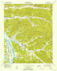
1936 Map of Chestnut Grove
USGS Topo · Published 1936About this map
The Buffalo River carves a winding path through this corner of Perry County, shaping a landscape of deep hollows and high ridges such as Burns Ridge. In the mid-1930s, the rural character of the region is evident in the network of family-named landmarks and small community centers like Beardstown and Chestnut Grove. This survey was compiled from aerial photographs by the Tennessee Valley Authority and the USGS, capturing the area during a period of infrastructure modernization. This is most notably represented by the presence of an Airway Beacon near the northern boundary and the alignment of Highway No 13.
Find a feature on this map
68 named features on this map. Tap any name to fly to it.
Don’t see what you’re looking for? This feature index may not catch every label — zoom into the map to look around manually.
Map Details
Editions of this 1936 Chestnut Grove Map
This is the sole edition of this map. No revisions or reprints were ever made.
Other maps of this area

1936 · Graves Spring
USGS Topo · 1:24,000

1936 · Pleasantville
USGS Topo · 1:24,000

1936 · Coble
USGS Topo · 1:24,000

1936 · Pine View
USGS Topo · 1:24,000

1936 · Daniels Landing
USGS Topo · 1:24,000

1936 · Linden
USGS Topo · 1:24,000

1936 · Lobelville
USGS Topo · 1:24,000

1936 · Pope
USGS Topo · 1:24,000
1949 · Pope
USGS Topo · 1:24,000

1949 · Daniels Landing
USGS Topo · 1:24,000