Old Maps of Perry County, Tennessee
Explore 121 old maps of Perry County, spanning from 1905 to today. These high-resolution historic maps reveal how streets, neighborhoods, landmarks, and natural features evolved over time — perfect for genealogy, metal detecting, research, and local history exploration.
What you can do with these maps:
- See how Perry County changed over time: Compare historical maps to modern-day views to trace roads, homesites, rail lines & more.
- View detailed metadata: Each map includes creators, publishers, year, scale, and archive source.
- Overlay maps with satellite & LiDAR: Visualize the past alongside modern tools to explore terrain & human change.
- Trusted historical sources: Maps sourced from the USGS, Library of Congress, and other archives.
- Access maps your way: View online, download high-res files, or order prints for personal or research use.
Start exploring old maps of Perry County to uncover forgotten places, hidden landmarks, and the deep history beneath your feet.
Perry County, TN maps
(121)- 1905 Map of Waynesboro
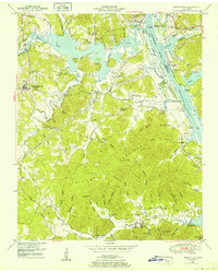
 1905 Waynesboro1905 Print · USGSWayne County and the Tennessee-Alabama borderlands are captured here at the start of the century, showing a network of river landings and old stage stands. Researchers can trace the Nathez Trace and locate historic community hubs like Martins Mills, Whittens Stand, and Clifton.2 unique versions available
 - 1936 Map of Graves Spring
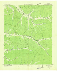
 1936 Graves Spring1936 Print · USGSMid-depression Tennessee highlands are captured here at the intersection of Perry, Lewis, and Hickman Counties. Researchers can locate remote family burial sites like Poplin Hollow Cem and early educational landmarks including Upper Coon Creek Sch.
 - 1936 Map of Pleasantville
 1936 Pleasantville1936 Print · USGSHickman County's rugged creek valleys are captured in the mid-1930s just as the Tennessee Valley Authority began modernizing the region. Local historians can trace old homesteads and community centers like Farmers Exchange, Pleasantville School, and the remote Bethel Church.
 - 1936 Map of Coble
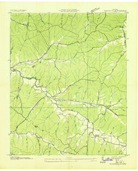
 1936 Coble1936 Print · USGSHickman County settlement is centered around the sinuous path of the Duck River during the mid-thirties. Researchers can trace family history through numerous sites like Only, Coble, Perogue Ford, and the Macedonia Sch.
 - 1936 Map of Pine View
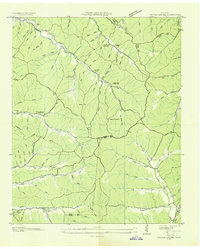
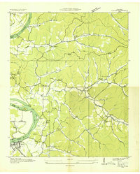
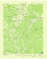
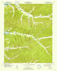
 1936 Pine View1936 Print · USGSPerry County's rural landscape is captured here in the mid-1930s, showing a community organized around the ridges and hollows of the Tennessee Valley. Genealogists can locate family landmarks like Bible Hill Cem, Nathan Sch, and the small settlement at Pine View.
 - 1936 Map of Bath Springs
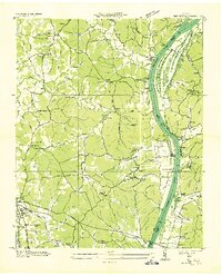
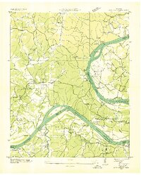 1936 Bath Springs1936 Print · USGSThe Tennessee River valley in the mid-1930s was a landscape defined by its river landings and rural crossroads. You can trace dozens of historic river access points like Furnace Landing and Jeter Landing alongside local landmarks like Bath Springs Ch.
 - 1936 Map of Daniels Landing
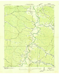
 1936 Daniels Landing1936 Print · USGSLife along the Tennessee River in the mid-1930s was defined by its landings and creek-side communities before major dam projects altered the valley. Genealogists can trace family landmarks like Britt Chapel Cem, Daniels Landing, and the school at Oakview Sch.
 - 1936 Map of Linden
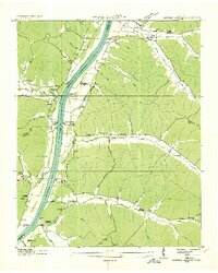
 1936 Linden1936 Print · USGSIn the mid-1930s, the Buffalo River valley in Perry County was a network of river fords and rural community centers. Researchers can trace ancestral locations at Webb Cem, Farmers Valley Ch, and river crossings like Washplace Ford or Sandfield Ford.
 - 1936 Map of Leatherwood
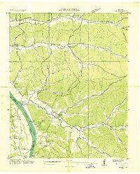
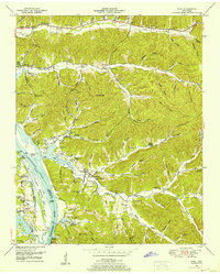
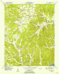
 1936 Leatherwood1936 Print · USGSThe Buffalo and Green River valleys of Wayne County were still a world of fords and ferries in the mid-1930s. Researchers can locate family landmarks like Holt Cem, the community at Flat Woods, and rural schools including Phillips Sch and Pope Sch.
 - 1936 Map of Clifton
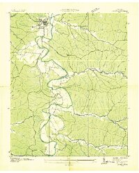
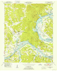
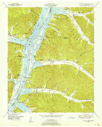
 1936 Clifton1936 Print · USGSThe Tennessee River corridor around Clifton was a network of active landings and rural ridge communities during the mid-1930s. Researchers can trace ancestral locations through several family-named cemeteries like Tucker Cem and Prater Cem, or map old river crossings such as Clifton Ferry.
 - 1936 Map of Chestnut Grove
 1936 Chestnut Grove1936 Print · USGSPerry County settlements and riverside farms are captured here in the mid-1930s as the Tennessee Valley Authority documented the local landscape. Genealogists can trace family footprints through sites like Beardstown, DePriest Cem, and the Warren Ch near the Buffalo River.
 - 1936 Map of Jeannette
 1936 Jeannette1936 Print · USGSDecatur County's riverbank communities and hills are captured here in the mid-thirties as the Tennessee River valley underwent significant change. Genealogists and historians can locate family landmarks like Walker Cem and trace the paths to Busseltown or Bells Store.
 - 1936 Map of Sugar Tree
 1936 Sugar Tree1936 Print · USGSDecatur and Benton counties are shown in the mid-thirties just as the TVA began its work along the river. Researchers can locate numerous family-named landmarks and community centers such as McIlwain, Hartley Cem, and Moore Chapel Sch.
 - 1936 Map of Lobelville
 1936 Lobelville1936 Print · USGSLobelville and the surrounding Buffalo River valley are captured here in the mid-1930s as the Tennessee Valley Authority began its regional work. Researchers can trace family sites like Davidson Cem, locate the Lobelville Mill & and Power House, and find rural landmarks like Terrapin Sch.
 - 1936 Map of Perryville
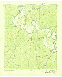
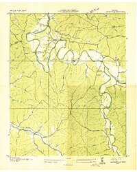
 1936 Perryville1936 Print · USGSDecatur County at the height of the Great Depression shows a river-dependent landscape centered on the Tennessee River. Researchers can locate several river landings and crossings, including Perryville Ferry and Mt Zion Cem.
 - 1936 Map of Topsy
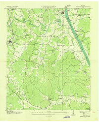
 1936 Topsy1936 Print · USGSWayne County was a network of river crossings and hollow-side farms in the mid-1930s before modern infrastructure altered the landscape. Researchers can trace ancestral roots at Topsy, locate rural hubs like Ashland, and find remote burial sites such as Zion Cem.
 - 1936 Map of Pope
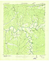
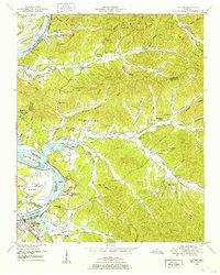
 1936 Pope1936 Print · USGSAlong the banks of the Tennessee River in the mid-1930s, this area supported a network of river landings and small valley settlements. Genealogists and historians can locate family-named landmarks like Simmons Cem, trace the location of the Old Furnace, and identify rural schools such as Gumdale Sch.
 - 1949 Map of Perryville, 1952 Print
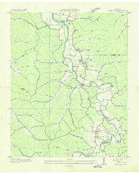
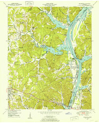
 1949 Perryville1952 Print · USGSDecatur County was undergoing significant transformation in the late 1940s as the Tennessee River valley adjusted to the creation of Kentucky Lake. Researchers can trace historic river landings like Jennings Bluff Landing, early industry at the Furnace, and rural landmarks such as Cypress Creek School.3 unique versions available
 - 1949 Map of Pope, 1952 Print
 1949 Pope1952 Print · USGSThe Tennessee River valley underwent a massive transformation in the mid-twentieth century as Kentucky Lake reshaped the Perry County shoreline. Researchers can trace old river connections at Brownsport Landing and locate vanished landmarks like the abandoned ore furnace stack and Gumdale School.2 unique versions available
 - 1949 Map of Bath Springs, 1952 Print
 1949 Bath Springs1952 Print · USGSThe Tennessee River corridor in the late 1940s shows a landscape of river landings and ridge-top settlements along the Decatur and Perry county lines. Genealogists can locate family-named landmarks like Lafferty Cemetery and Tuckers Store or trace the rural river economy at Yarbro Landing.3 unique versions available
 - 1949 Map of Clifton, 1952 Print
 1949 Clifton1952 Print · USGSThe riverfront town of Clifton and its surrounding ridges are captured in the late 1940s as the Tennessee River valley adapted to the impacts of Kentucky Lake. Genealogists can trace family landmarks and community nodes like Peters Landing, New Zion Ch, and the Lone Chestnut Cem.4 unique versions available
 - 1949 Map of Daniels Landing, 1953 Print
 1949 Daniels Landing1953 Print · USGSWest Tennessee river life is captured here in the late 1940s as the valley adapted to the creation of Kentucky Lake. Researchers can trace old family sites and river landings such as Daniels Landing, Blue Creek School, and Britta Chapel.3 unique versions available
 - 1949 Map of Jeannette, 1953 Print
 1949 Jeannette1953 Print · USGSDecatur County's riverfront landscape is shown here in the late 1940s as the Tennessee River valley adjusted to the presence of Kentucky Lake. Genealogists and historians can trace family locations through Rocky Hill School, Salem Ch, and the Dismantled RR near Parsons.2 unique versions available
 - 1949 Map of Pine View, 1953 Print
 1949 Pine View1953 Print · USGSPerry County's rural interior is documented here in the early postwar years as the Tennessee Valley Authority shaped the local landscape. Researchers can trace ancestral roots through family-named hollows and sites like Nathan Sch, Bible Hill Cem, and the Lick Creek Ch.2 unique versions available
 - 1949 Map of Sugar Tree, 1953 Print
 1949 Sugar Tree1953 Print · USGSBenton and Decatur Counties are captured in the late 1940s, showing a landscape of deep hollows and high ridges along the Tennessee River. Genealogists can trace family names at Manley Chapel Cemetery and locate vanished local landmarks like Spences Store or Mellwain.2 unique versions available
Showing maps 1-25 of 121
Top cities of Perry County
Frequently asked questions
- What are the different types of historical maps available for Perry County?
- What is the oldest map of Perry County?
- Where can I purchase historical maps of Perry County for my home or office?
- Where can I download high-res historical maps of Perry County?
- Are there historical topographic maps available for Perry County?
- Is there historical aerial imagery available for Perry County?
- Where are historical maps of Perry County sourced from?