1930s Maps of Estill Springs, Tennessee
Explore 4 historic maps of Estill Springs from the 1930s. These maps offer a rare glimpse into what life looked like during the 1930s — showing old roads, neighborhoods, homes, and landmarks that have changed or disappeared over time.
Whether you're researching your family's past, planning a metal detecting trip, or studying how Estill Springs's landscape evolved across the 1930s, these high-resolution maps are a powerful tool for exploring the history of this region.
- Focus on a specific era: All maps on this page are from the 1930s, giving you a focused view of this time period.
- See what’s changed: Compare century-old streets, trails, and buildings to today's modern landscape using overlays and satellite layers.
- Research with precision: Use these maps for genealogy, historical research, land use analysis, or educational projects.
- View, download, or print: Maps are fully viewable online in high resolution, and can be downloaded or printed for your own records.
Start exploring Estill Springs's history through authentic maps from the 1930s. This is your window into the past.
Estill Springs, TN maps
(4)- 1936 Map of Winchester
 1936 Winchester1936 Print · USGSFranklin County's rail-connected towns of Winchester and Decherd are shown here in the mid-1930s as they transition during the TVA era. Genealogists can trace numerous local landmarks including Pig Trot Sch, Owen Chapel, and the Mc Illhearn Cem.
 - 1936 Map of Belvidere
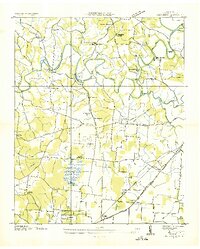 1936 Belvidere1936 Print · USGSFranklin County's rural landscape is captured here in the mid-1930s as a network of river-bottom farms and small rail towns. Genealogists can locate family landmarks like Sorrick Cem, Owl Hollow Mill, and the Winchester Springs Sch along the river.
 - 1936 Map of Camp Peay
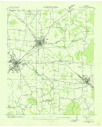
 1936 Camp Peay1936 Print · USGSIn the mid-1930s, the area around Tullahoma and Estill Springs was a hub of military and rail activity. Genealogists and historians can trace the National Guard Reservation at Camp Peay, family burial sites like Maplewood Cem, and local landmarks including the Girls Vocational Sch.
 - 1936 Map of Capitol Hill
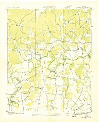 1936 Capitol Hill1936 Print · USGSThe Tennessee Valley during the mid-1930s shows a landscape of river-dependent industry and small rural crossroads. Genealogists can trace family roots through landmarks like Knight Ch, Call Sch, and the riverside operations at Dixon Mill.
End of results
Showing maps 1-4 of 4
Top cities near Estill Springs
- Tullahoma historical maps
- Manchester historical maps
- Winchester historical maps
- Sewanee historical maps
- Decherd historical maps
- Cowan historical maps
See more
Top neighborhoods of Estill Springs
- Taylor Creek East Subdivision historical maps
- Taylor Creek West Subdivision historical maps
- Elkins historical maps
Frequently asked questions
- What are the different types of historical maps available for Estill Springs?
- What is the oldest map of Estill Springs?
- Where can I purchase historical maps of Estill Springs for my home or office?
- Where can I download high-res historical maps of Estill Springs?
- Are there historical topographic maps available for Estill Springs?
- Is there historical aerial imagery available for Estill Springs?
- Where are historical maps of Estill Springs sourced from?