1940s Maps of Estill Springs, Tennessee
Explore 5 historic maps of Estill Springs from the 1940s. These maps offer a rare glimpse into what life looked like during the 1940s — showing old roads, neighborhoods, homes, and landmarks that have changed or disappeared over time.
Whether you're researching your family's past, planning a metal detecting trip, or studying how Estill Springs's landscape evolved across the 1940s, these high-resolution maps are a powerful tool for exploring the history of this region.
- Focus on a specific era: All maps on this page are from the 1940s, giving you a focused view of this time period.
- See what’s changed: Compare century-old streets, trails, and buildings to today's modern landscape using overlays and satellite layers.
- Research with precision: Use these maps for genealogy, historical research, land use analysis, or educational projects.
- View, download, or print: Maps are fully viewable online in high resolution, and can be downloaded or printed for your own records.
Start exploring Estill Springs's history through authentic maps from the 1940s. This is your window into the past.
Estill Springs, TN maps
(5)- 1941 Map of Capitol Hill, 1942 Print
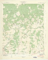 1941 Capitol Hill1942 Print · USGSFranklin County at the start of the war shows a landscape transitioning between rural life and military expansion. Genealogists can trace family roots through Capitol Hill, Paynes, and Buncombe, or locate landmarks like the Estill Springs Power Plant.3 unique versions available
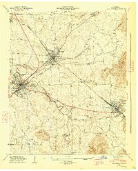
 - 1941 Map of Camp Forrest, 1943 Print
 1941 Camp Forrest1943 Print · USGSThe Tennessee mobilization of the early 1940s is on full display as the Camp Forrest Military Reservation rises near Tullahoma. Genealogists and historians can trace family-named sites like Holt Cem and Pylant Springs before the landscape was fully altered by military expansion.2 unique versions available
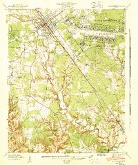
 - 1943 Map of Mc Minnville, 1944 Print
 1943 Mc Minnville1944 Print · USGSMid-Tennessee is captured here during the mobilization of the early 1940s, showing the vast Camp Forrest Military Reservation and thriving rail towns. Trace the N C & ST L line through Mcminnville or locate smaller rural hubs like Morrison and Hickerson Station.
 - 1947 Map of Winchester, 1948 Print
 1947 Winchester1948 Print · USGSFranklin County in the late 1940s is captured at a point of industrial and municipal expansion along the Nashville Chattanooga and St Louis railway. Researchers can trace family history through local landmarks like Cedar Bluff Mill, the County Fairgrounds, and numerous cemeteries including Mt Garner Cem.3 unique versions available
 - 1947 Map of Belvidere, 1948 Print
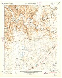 1947 Belvidere1948 Print · USGSFranklin County's rural landscape is captured here in the late 1940s, just as the river valley and rail networks supported a series of small, thriving communities. Genealogists can trace family names at Owl Hollow Mill, Winchester Springs, and the Franklin Cem.4 unique versions available
End of results
Showing maps 1-5 of 5
Top cities near Estill Springs
- Tullahoma historical maps
- Manchester historical maps
- Winchester historical maps
- Sewanee historical maps
- Decherd historical maps
- Cowan historical maps
See more
Top neighborhoods of Estill Springs
- Taylor Creek East Subdivision historical maps
- Taylor Creek West Subdivision historical maps
- Elkins historical maps
Frequently asked questions
- What are the different types of historical maps available for Estill Springs?
- What is the oldest map of Estill Springs?
- Where can I purchase historical maps of Estill Springs for my home or office?
- Where can I download high-res historical maps of Estill Springs?
- Are there historical topographic maps available for Estill Springs?
- Is there historical aerial imagery available for Estill Springs?
- Where are historical maps of Estill Springs sourced from?