1900s (20th Century) Maps of Pulaski, Tennessee
Explore 9 historic maps of Pulaski from the 1900s (20th Century). These maps offer a rare glimpse into what life looked like during the 1900s — showing old roads, neighborhoods, homes, and landmarks that have changed or disappeared over time.
Whether you're researching your family's past, planning a metal detecting trip, or studying how Pulaski's landscape evolved across the 1900s, these high-resolution maps are a powerful tool for exploring the history of this region.
- Focus on a specific era: All maps on this page are from the 1900s, giving you a focused view of this time period.
- See what’s changed: Compare century-old streets, trails, and buildings to today's modern landscape using overlays and satellite layers.
- Research with precision: Use these maps for genealogy, historical research, land use analysis, or educational projects.
- View, download, or print: Maps are fully viewable online in high resolution, and can be downloaded or printed for your own records.
Start exploring Pulaski's history through authentic maps from the 1900s. This is your window into the past.
Pulaski, TN maps
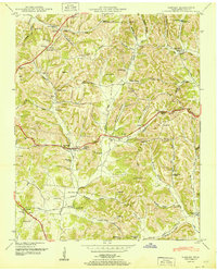
(9)- 1936 Map of Pulaski
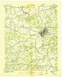 1936 Pulaski1936 Print · USGSGiles County was undergoing a significant transformation in the mid-1930s as modern utilities arrived. Genealogists and historians can trace family roots through Peterson Cem, Goodspring Ch, and numerous rural schoolhouses like Rock City Sch.
 - 1936 Map of Tarpley
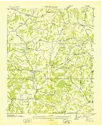 1936 Tarpley1936 Print · USGSGiles County in the mid-1930s was a landscape of small upland farms and tightly-knit rural communities. Genealogists and local historians can trace family locations through named sites like Aymett Town, Beech Hill Sch, and Hopkins Cem.
 - 1948 Map of Tarpley, 1974 Print
 1948 Tarpley1974 Print · USGSGiles County life in the late 1940s centered on hilltop settlements and creek-side farms along Pigeon Roost Creek. Trace family roots at Beech Hill, find old churches like Rocky Mount Ch, and locate the historic Stage Road.2 unique versions available
 - 1951 Map of Pulaski
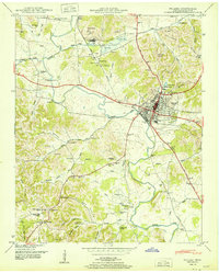 1951 Pulaski1951 Print · USGSGiles County at mid-century reveals a landscape shaped by the Louisville and Nashville railroad and the growth of Pulaski. Genealogists can locate family landmarks such as Maplewood Cem, Anthony Hill School, and Zuccarella Cem.
 - 1951 Map of Tarpley
 1951 Tarpley1951 Print · USGSGiles County at the mid-century reveals a rural landscape of ridges and hollows defined by long-established family names and crossroads communities. Trace genealogical roots through dozens of local sites like Aymett Town, New Zion School, and the Rocky Mount Cem.
 - 1956 Map of Columbia, 1960 Print
 1956 Columbia1960 Print · USGSMiddle Tennessee in the mid-fifties presents a landscape of established river towns and critical rail hubs before the arrival of the modern interstate system. Researchers can trace the routes of the Louisville and Nashville railroad or locate historic landmarks like Stones River National Military Park and the Tennessee National Wildlife Refuge.6 unique versions available
 - 1966 Map of Pulaski, 1968 Print
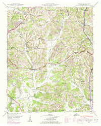
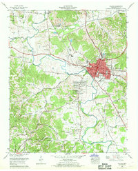 1966 Pulaski1968 Print · USGSMid-century Pulaski and the surrounding Giles County hills are captured here just as post-war suburban additions like Rebel Acres began to expand. Genealogists can trace family names through dozens of rural landmarks, from Peterson Cem and Meredith Cem to the tracks of the Louisville and Nashville Railroad.3 unique versions available
 - 1981 Map of Tullahoma, 1982 Print
 1981 Tullahoma1982 Print · USGSSouthern Tennessee enters the 1980s with a mix of aerospace technology and deep rural roots. Researchers can trace the L & N RR through Shelbyville and Fayetteville or locate family sites like Old Salem Cem and Blanton Chapel near the Cumberland Plateau.
 - 1985 Map of Lawrenceburg
 1985 Lawrenceburg1985 Print · USGSMiddle Tennessee and Northern Alabama are captured in the mid-1980s, showcasing a landscape of high ridges and winding river valleys. Genealogists and historians can trace rail lines like the Seaboard System Railroad or locate community landmarks such as Saint Marys Church and Three Churches.2 unique versions available
End of results
Showing maps 1-9 of 9
Top cities near Pulaski
- Ardmore historical maps
- Cornersville historical maps
- Elkton historical maps
- Minor Hill historical maps
- Lynnville historical maps
- Lester historical maps
Top neighborhoods of Pulaski
- Glendale Estates historical maps
- Gordon historical maps
- Green Acres historical maps
- Highland Heights historical maps
- Lancelot Acres historical maps
- Rebel Acres historical maps
See more
Frequently asked questions
- What are the different types of historical maps available for Pulaski?
- What is the oldest map of Pulaski?
- Where can I purchase historical maps of Pulaski for my home or office?
- Where can I download high-res historical maps of Pulaski?
- Are there historical topographic maps available for Pulaski?
- Is there historical aerial imagery available for Pulaski?
- Where are historical maps of Pulaski sourced from?