1930s Maps of Bowen, Tennessee
Explore 4 historic maps of Bowen from the 1930s. These maps offer a rare glimpse into what life looked like during the 1930s — showing old roads, neighborhoods, homes, and landmarks that have changed or disappeared over time.
Whether you're researching your family's past, planning a metal detecting trip, or studying how Bowen's landscape evolved across the 1930s, these high-resolution maps are a powerful tool for exploring the history of this region.
- Focus on a specific era: All maps on this page are from the 1930s, giving you a focused view of this time period.
- See what’s changed: Compare century-old streets, trails, and buildings to today's modern landscape using overlays and satellite layers.
- Research with precision: Use these maps for genealogy, historical research, land use analysis, or educational projects.
- View, download, or print: Maps are fully viewable online in high resolution, and can be downloaded or printed for your own records.
Start exploring Bowen's history through authentic maps from the 1930s. This is your window into the past.
Bowen, TN maps
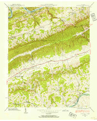
(4)- 1935 Map of Tate Springs
 1935 Tate Springs1935 Print · USGSThe river valleys of Grainger County are captured here in the mid-1930s as the Tennessee Valley Authority began planning the reservoir. Trace family history through local landmarks like Lawson Mill, Swan Island Ferry, and the community at Tate Springs.
 - 1935 Map of Avondale
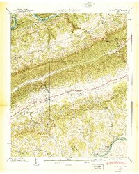
 1935 Avondale1935 Print · USGSGrainger County is captured here in the mid-1930s as the rising Norris Reservoir began to reshape the landscape. Local historians can locate vanished landmarks like Avondale Sch, Shields Cem, and the original crossing at Turley Bridge.
 - 1938 Map of Avondale, 1954 Print
 1938 Avondale1954 Print · USGSEast Tennessee's ridge-and-valley landscape is frozen in time during the late 1930s as the Tennessee Valley Authority began transforming the region's river systems. Researchers can trace ancestral locations through the Avondale Cem, local schools like Prospect Sch, and landmarks including Turley Mill and Idol Cross Roads.
 - 1939 Map of Avondale
 1939 Avondale1939 Print · USGSGrainger County in the late thirties shows a landscape shaped by the new Norris Reservoir and ancient Appalachian ridges. Family historians can locate dozens of specific sites including Avondale Cem, Turley Mill, and schools like Clinch Mtn Sch.2 unique versions available
End of results
Showing maps 1-4 of 4
Top cities near Bowen
- Morristown historical maps
- Jefferson City historical maps
- Bean Station historical maps
- New Tazewell historical maps
- White Pine historical maps
- Tazewell historical maps
See more
Frequently asked questions
- What are the different types of historical maps available for Bowen?
- What is the oldest map of Bowen?
- Where can I purchase historical maps of Bowen for my home or office?
- Where can I download high-res historical maps of Bowen?
- Are there historical topographic maps available for Bowen?
- Is there historical aerial imagery available for Bowen?
- Where are historical maps of Bowen sourced from?