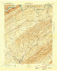
1940s Maps of Greene County, Tennessee
Explore 10 historic maps of Greene County from the 1940s. These maps offer a rare glimpse into what life looked like during the 1940s — showing old roads, neighborhoods, homes, and landmarks that have changed or disappeared over time.
Whether you're researching your family's past, planning a metal detecting trip, or studying how Greene County's landscape evolved across the 1940s, these high-resolution maps are a powerful tool for exploring the history of this region.
- Focus on a specific era: All maps on this page are from the 1940s, giving you a focused view of this time period.
- See what’s changed: Compare century-old streets, trails, and buildings to today's modern landscape using overlays and satellite layers.
- Research with precision: Use these maps for genealogy, historical research, land use analysis, or educational projects.
- View, download, or print: Maps are fully viewable online in high resolution, and can be downloaded or printed for your own records.
Start exploring Greene County's history through authentic maps from the 1940s. This is your window into the past.
Greene County, TN maps
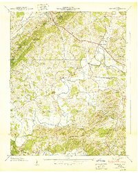
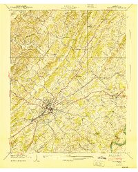
(10)- 1940 Map of Stony Point
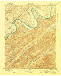 1940 Stony Point1940 Print · USGSHawkins County is captured here just before the mid-century, where the winding Holston River meets a landscape of steep mountain ridges and fertile valley bottoms. Genealogists and local historians can locate Surgoinsville, trace the old Southern Railroad, and find rural landmarks like Mowls Mill and Maxwell Academy.
 - 1940 Map of Baileyton
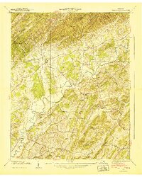 1940 Baileyton1940 Print · USGSGreene County agriculture and mountain life are captured here just before the mid-century, showing the tightly-knit network of mills and valley schools. Researchers can trace family sites near Lick Creek Mill, Wesley Chapel, and Brittontown Sch.
 - 1940 Map of Parrottsville
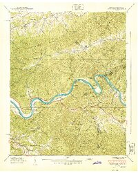
 1940 Parrottsville1940 Print · USGSEast Tennessee river life and mountain hollows are captured here just as the Tennessee Valley Authority began its regional transformations. Genealogists can trace family roots through an extensive network of landmarks including Brookside Mill, Ottinger Cem, and Harned Chapel.
 - 1940 Map of Paint Rock
 1940 Paint Rock1940 Print · USGSThe French Broad River valley at the Tennessee-North Carolina border is captured here during the 1940s, showing a landscape of mountain gaps and riverside rail settlements. Family historians can locate family plots and early rural schools like Mooneyham Cem, Justis Cem, and the Fugate Sch.4 unique versions available
 - 1940 Map of Mohawk
 1940 Mohawk1940 Print · USGSEast Tennessee at the dawn of the 1940s reveals a landscape of tight-knit rural communities connected by the SOUTHERN railroad. Genealogists can locate family landmarks like Darrow Mill, Crosby Cem, and several local schoolhouses like Salem Sch.
 - 1940 Map of Davy Crockett Lake
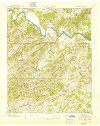
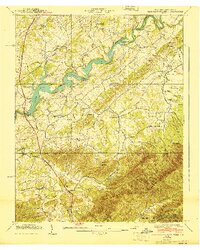 1940 Davy Crockett Lake1940 Print · USGSGreene County, Tennessee, is captured here in the early 1940s just as the Nolichucky River valley was being reshaped by the waters of Lake Davy Crockett. Trace family roots and local history through features like Cove Creek Mill, Price Cem, and the Orphanage.
 - 1940 Map of Mc Cloud
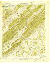 1940 Mc Cloud1940 Print · USGSJust before the mid-century, this corner of East Tennessee shows a landscape defined by the Bays Mountains and rural agriculture. Genealogists can trace family names at Patterson Cem or locate community hubs like Romeo and Bandy Chapel.
 - 1940 Map of Hot Springs
 1940 Hot Springs1940 Print · USGSMadison County and the Tennessee borderlands are captured here in the early 1940s, showing the intersection of mountain life and federal work projects. Researchers can trace family history through sites like CCC Camp No F 7, Hurricane Chapel, and the riverfront settlement at Stackhouse.6 unique versions available
 - 1940 Map of Greeneville
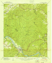
 1940 Greeneville1940 Print · USGSGreeneville and the surrounding Greene County landscape are captured here in the era just before the mid-century, centered on the Southern rail line. Genealogists and historians can locate family landmarks like Tusculum College, Staunton Mill, and the Andrew Johnson National Monument.
 - 1940 Map of Bulls Gap
 1940 Bulls Gap1940 Print · USGSBulls Gap and the Hawkins County countryside are captured here just before the 1940s, showing a landscape defined by the Southern railroad and river life. Genealogists can trace family names across dozens of sites like Mcbride Cem, Austins Mill, and the Price Ferry on the Holston River.2 unique versions available
End of results
Showing maps 1-10 of 10
Top cities of Greene County
Frequently asked questions
- What are the different types of historical maps available for Greene County?
- What is the oldest map of Greene County?
- Where can I purchase historical maps of Greene County for my home or office?
- Where can I download high-res historical maps of Greene County?
- Are there historical topographic maps available for Greene County?
- Is there historical aerial imagery available for Greene County?
- Where are historical maps of Greene County sourced from?