1970s Maps of Hamblen County, Tennessee
Explore 2 historic maps of Hamblen County from the 1970s. These maps offer a rare glimpse into what life looked like during the 1970s — showing old roads, neighborhoods, homes, and landmarks that have changed or disappeared over time.
Whether you're researching your family's past, planning a metal detecting trip, or studying how Hamblen County's landscape evolved across the 1970s, these high-resolution maps are a powerful tool for exploring the history of this region.
- Focus on a specific era: All maps on this page are from the 1970s, giving you a focused view of this time period.
- See what’s changed: Compare century-old streets, trails, and buildings to today's modern landscape using overlays and satellite layers.
- Research with precision: Use these maps for genealogy, historical research, land use analysis, or educational projects.
- View, download, or print: Maps are fully viewable online in high resolution, and can be downloaded or printed for your own records.
Start exploring Hamblen County's history through authentic maps from the 1970s. This is your window into the past.
Hamblen County, TN maps
(2)- 1979 Map of Avondale, 1980 Print
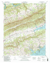 1979 Avondale1980 Print · USGSGrainger County is captured here in the late seventies, showing the traditional farming communities and ridges between the Clinch and Holston Rivers. Trace family roots and local landmarks through dozens of sites like the Dotson Campground Church, Avondale Lookout Tower, and Slave Cem.2 unique versions available
 - 1979 Map of Morristown, 1980 Print
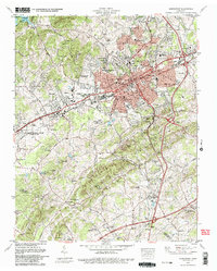 1979 Morristown1980 Print · USGSMorristown and its surrounding East Tennessee hills are captured in the late seventies as the region balanced industrial growth with its rural heritage. Genealogists and local historians can trace family names at Emma Jarragin Cem, Sartain Springs Ch, and Hales Crossroads.2 unique versions available
End of results
Showing maps 1-2 of 2
Top cities of Hamblen County
Frequently asked questions
- What are the different types of historical maps available for Hamblen County?
- What is the oldest map of Hamblen County?
- Where can I purchase historical maps of Hamblen County for my home or office?
- Where can I download high-res historical maps of Hamblen County?
- Are there historical topographic maps available for Hamblen County?
- Is there historical aerial imagery available for Hamblen County?
- Where are historical maps of Hamblen County sourced from?