1940s Maps of Forest Highlands, Chattanooga
Explore 2 historic maps of Forest Highlands from the 1940s. These maps offer a rare glimpse into what life looked like during the 1940s — showing old roads, neighborhoods, homes, and landmarks that have changed or disappeared over time.
Whether you're researching your family's past, planning a metal detecting trip, or studying how Forest Highlands's landscape evolved across the 1940s, these high-resolution maps are a powerful tool for exploring the history of this region.
- Focus on a specific era: All maps on this page are from the 1940s, giving you a focused view of this time period.
- See what’s changed: Compare century-old streets, trails, and buildings to today's modern landscape using overlays and satellite layers.
- Research with precision: Use these maps for genealogy, historical research, land use analysis, or educational projects.
- View, download, or print: Maps are fully viewable online in high resolution, and can be downloaded or printed for your own records.
Start exploring Forest Highlands's history through authentic maps from the 1940s. This is your window into the past.
Forest Highlands, Chattanooga maps
(2)- 1940 Map of Chattanooga
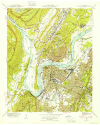 1940 Chattanooga1940 Print · USGSChattanooga and the Tennessee River valley are captured here at the dawn of the 1940s, showcasing a bustling rail and river hub. Researchers can trace the legacy of Union Station, find family plots in National Cem, or locate the historic Cravens House on the slopes of Lookout Mountain.2 unique versions available
 - 1941 Map of Chattanooga
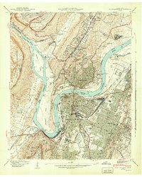 1941 Chattanooga1941 Print · USGSChattanooga was a powerhouse of rail and river industry just before the Second World War. Genealogists and historians can trace the early city grid from Union Station to MISSIONARY RIDGE, locating landmarks like Ruby Falls and National Cem.5 unique versions available
End of results
Showing maps 1-2 of 2
Top cities near Forest Highlands
- Chattanooga historical maps
- East Ridge historical maps
- East Ridge historical maps
- Soddy-Daisy historical maps
- Fort Oglethorpe historical maps
- Collegedale historical maps
See more
Frequently asked questions
- What are the different types of historical maps available for Forest Highlands?
- What is the oldest map of Forest Highlands?
- Where can I purchase historical maps of Forest Highlands for my home or office?
- Where can I download high-res historical maps of Forest Highlands?
- Are there historical topographic maps available for Forest Highlands?
- Is there historical aerial imagery available for Forest Highlands?
- Where are historical maps of Forest Highlands sourced from?