1940s Maps of Ooltewah, Collegedale
Explore 2 historic maps of Ooltewah from the 1940s. These maps offer a rare glimpse into what life looked like during the 1940s — showing old roads, neighborhoods, homes, and landmarks that have changed or disappeared over time.
Whether you're researching your family's past, planning a metal detecting trip, or studying how Ooltewah's landscape evolved across the 1940s, these high-resolution maps are a powerful tool for exploring the history of this region.
- Focus on a specific era: All maps on this page are from the 1940s, giving you a focused view of this time period.
- See what’s changed: Compare century-old streets, trails, and buildings to today's modern landscape using overlays and satellite layers.
- Research with precision: Use these maps for genealogy, historical research, land use analysis, or educational projects.
- View, download, or print: Maps are fully viewable online in high resolution, and can be downloaded or printed for your own records.
Start exploring Ooltewah's history through authentic maps from the 1940s. This is your window into the past.
Ooltewah, Collegedale maps
(2)- 1940 Map of Ooltewah, 1954 Print
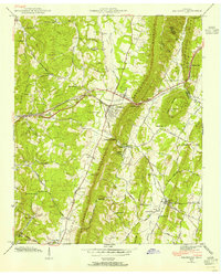 1940 Ooltewah1954 Print · USGSSoutheast Tennessee is captured here just before the mid-century as a landscape of ridge-and-valley farming and emerging education. Genealogists can trace family names at Sylar Cem and Pollard Cem or locate the early campus of Southern Junior College.
 - 1941 Map of Ooltewah
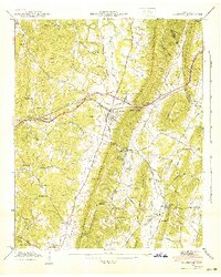 1941 Ooltewah1941 Print · USGSThe valleys and ridges of Hamilton and Bradley counties are shown here just before the mid-century industrial boom. Genealogists can locate family names and sites like Bell Mill, Mineral Park Chapel, and the campus of Southern Junior College.
End of results
Showing maps 1-2 of 2
Top cities near Ooltewah
- Chattanooga historical maps
- Cleveland historical maps
- East Ridge historical maps
- East Ridge historical maps
- Soddy-Daisy historical maps
- Fort Oglethorpe historical maps
See more
Frequently asked questions
- What are the different types of historical maps available for Ooltewah?
- What is the oldest map of Ooltewah?
- Where can I purchase historical maps of Ooltewah for my home or office?
- Where can I download high-res historical maps of Ooltewah?
- Are there historical topographic maps available for Ooltewah?
- Is there historical aerial imagery available for Ooltewah?
- Where are historical maps of Ooltewah sourced from?