1940s Maps of Savannah, Tennessee
Explore 2 historic maps of Savannah from the 1940s. These maps offer a rare glimpse into what life looked like during the 1940s — showing old roads, neighborhoods, homes, and landmarks that have changed or disappeared over time.
Whether you're researching your family's past, planning a metal detecting trip, or studying how Savannah's landscape evolved across the 1940s, these high-resolution maps are a powerful tool for exploring the history of this region.
- Focus on a specific era: All maps on this page are from the 1940s, giving you a focused view of this time period.
- See what’s changed: Compare century-old streets, trails, and buildings to today's modern landscape using overlays and satellite layers.
- Research with precision: Use these maps for genealogy, historical research, land use analysis, or educational projects.
- View, download, or print: Maps are fully viewable online in high resolution, and can be downloaded or printed for your own records.
Start exploring Savannah's history through authentic maps from the 1940s. This is your window into the past.
Savannah, TN maps
(2)- 1949 Map of Pittsburg Landing, 1952 Print
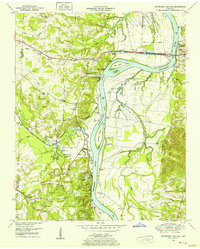 1949 Pittsburg Landing1952 Print · USGSHardin County history is centered on the hallowed grounds of Shiloh National Military Park and the vital banks of the Tennessee River in the late 1940s. Genealogists and historians can trace the riverside at Pittsburg Landing, locate the National Cem, or find rural family sites like Ledbetter Cem and Mt Zion Ch.
 - 1949 Map of Savannah, 1952 Print
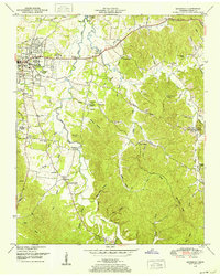 1949 Savannah1952 Print · USGSHardin County during the late 1940s shows a landscape of riverfront growth near the Tennessee River and scattered rural hamlets. You can trace early family sites and community centers like Burnt Church, Walkertown, and the Sevier Chapel School.
End of results
Showing maps 1-2 of 2
Top cities near Savannah
- Corinth historical maps
- Clifton historical maps
- Adamsville historical maps
- Crump historical maps
- Michie historical maps
- Sardis historical maps
See more
Top neighborhoods of Savannah
- Phillips historical maps
- Belle Meade historical maps
- Woodland Heights historical maps
- New Town historical maps
- Austin historical maps
Frequently asked questions
- What are the different types of historical maps available for Savannah?
- What is the oldest map of Savannah?
- Where can I purchase historical maps of Savannah for my home or office?
- Where can I download high-res historical maps of Savannah?
- Are there historical topographic maps available for Savannah?
- Is there historical aerial imagery available for Savannah?
- Where are historical maps of Savannah sourced from?