1970s Maps of Savannah, Tennessee
Explore 2 historic maps of Savannah from the 1970s. These maps offer a rare glimpse into what life looked like during the 1970s — showing old roads, neighborhoods, homes, and landmarks that have changed or disappeared over time.
Whether you're researching your family's past, planning a metal detecting trip, or studying how Savannah's landscape evolved across the 1970s, these high-resolution maps are a powerful tool for exploring the history of this region.
- Focus on a specific era: All maps on this page are from the 1970s, giving you a focused view of this time period.
- See what’s changed: Compare century-old streets, trails, and buildings to today's modern landscape using overlays and satellite layers.
- Research with precision: Use these maps for genealogy, historical research, land use analysis, or educational projects.
- View, download, or print: Maps are fully viewable online in high resolution, and can be downloaded or printed for your own records.
Start exploring Savannah's history through authentic maps from the 1970s. This is your window into the past.
Savannah, TN maps
(2)- 1972 Map of Savannah, 1974 Print
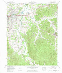 1972 Savannah1974 Print · USGSHardin County and the city of Savannah are captured here during a period of local growth in the early seventies. Genealogists and historians can trace family roots through numerous small burial grounds and rural landmarks like Sand Hill Cem, Plummer Church, and Old Town.2 unique versions available
 - 1972 Map of Pittsburg Landing, 1974 Print
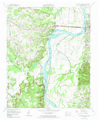 1972 Pittsburg Landing1974 Print · USGSHardin County during the early seventies reveals a landscape defined by the Tennessee River and the sacred grounds of Shiloh National Military Park. Historians can trace rural community life through sites like Pittsburg Landing, Bethlehem Cem, and Crump Landing.2 unique versions available
End of results
Showing maps 1-2 of 2
Top cities near Savannah
- Corinth historical maps
- Clifton historical maps
- Adamsville historical maps
- Crump historical maps
- Michie historical maps
- Sardis historical maps
See more
Top neighborhoods of Savannah
- Phillips historical maps
- Belle Meade historical maps
- Woodland Heights historical maps
- New Town historical maps
- Austin historical maps
Frequently asked questions
- What are the different types of historical maps available for Savannah?
- What is the oldest map of Savannah?
- Where can I purchase historical maps of Savannah for my home or office?
- Where can I download high-res historical maps of Savannah?
- Are there historical topographic maps available for Savannah?
- Is there historical aerial imagery available for Savannah?
- Where are historical maps of Savannah sourced from?