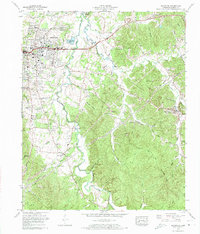
1972 Map of Savannah
USGS Topo · Published 1974About this map
The Tennessee River city of Savannah is the focal point of this 1970s survey, showing a landscape defined by significant postwar expansion and river-related geography. The city’s residential reach extends into neighborhoods like Woodland Heights, New Town, and Belle Meade, while the Hardin County General Hospital and Central High School mark the community's civic core. Beyond the city limits, the terrain transitions into the creek-carved hollows of the eastern hills, such as Owen Hollow and Jenkins Hollow, where smaller settlements like Olivet and Maddox persist. To the north, the presence of Kentucky Lake influences the local drainage, while numerous family-named burial grounds like Smith Cem and Doran Cem are scattered across the landscape, providing essential data for those researching Hardin County's ancestral homesteads and rural church communities like Burnt Church.
Find a feature on this map
82 named features on this map. Tap any name to fly to it.
Don’t see what you’re looking for? This feature index may not catch every label — zoom into the map to look around manually.
Map Details
Editions of this 1972 Savannah Map
2 editions found
Other maps of this area

1936 · Savannah
USGS Topo · 1:24,000

1936 · Wolf Pit Ridge
USGS Topo · 1:24,000

1936 · Hookers Bend
USGS Topo · 1:24,000

1936 · Counce
USGS Topo · 1:24,000

1936 · Olivehill
USGS Topo · 1:24,000

1936 · Milledgeville
USGS Topo · 1:24,000

1936 · Pickwick
USGS Topo · 1:24,000

1936 · Lowryville
USGS Topo · 1:24,000

1936 · Pittsburg Landing
USGS Topo · 1:24,000

1949 · Hookers Bend
USGS Topo · 1:24,000