1900s (20th Century) Maps of Parkers Crossroads, Tennessee
Explore 7 historic maps of Parkers Crossroads from the 1900s (20th Century). These maps offer a rare glimpse into what life looked like during the 1900s — showing old roads, neighborhoods, homes, and landmarks that have changed or disappeared over time.
Whether you're researching your family's past, planning a metal detecting trip, or studying how Parkers Crossroads's landscape evolved across the 1900s, these high-resolution maps are a powerful tool for exploring the history of this region.
- Focus on a specific era: All maps on this page are from the 1900s, giving you a focused view of this time period.
- See what’s changed: Compare century-old streets, trails, and buildings to today's modern landscape using overlays and satellite layers.
- Research with precision: Use these maps for genealogy, historical research, land use analysis, or educational projects.
- View, download, or print: Maps are fully viewable online in high resolution, and can be downloaded or printed for your own records.
Start exploring Parkers Crossroads's history through authentic maps from the 1900s. This is your window into the past.
Parkers Crossroads, TN maps
(7)- 1936 Map of Clarksburg
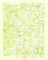 1936 Clarksburg1936 Print · USGSWest Tennessee’s rural landscape comes alive in the mid-1930s, showing the early road networks and community hubs of Carroll and Henderson Counties. Genealogists can locate family-named landmarks like Hart Cem and schools including Pritchard Sch and Clarksburg Sch.
 - 1936 Map of Lexington
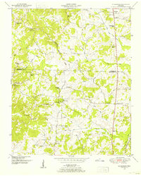
 1936 Lexington1936 Print · USGSHenderson County in the mid-thirties reveals a landscape of rural schoolhouses and busy rail junctions centered on the town of Lexington. Genealogists can trace family landmarks like Caffey Cem or visit the site of the CCC Camp No 496.
 - 1950 Map of Lexington, 1953 Print
 1950 Lexington1953 Print · USGSHenderson County is captured here in the mid-century as a landscape of crossroads, railroads, and ridge-line communities. Genealogists can trace family names and local landmarks through the Old Hephzibah Cem, Timberlake School, and the busy rail junction at Lexington.3 unique versions available
 - 1950 Map of Clarksburg, 1953 Print
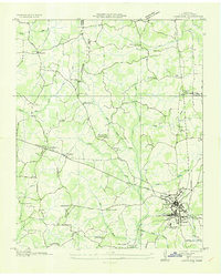
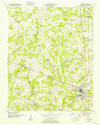
 1950 Clarksburg1953 Print · USGSWest Tennessee rural life is documented here at mid-century, where the Tennessee Valley Divide separates the river systems of Carroll and Henderson Counties. Researchers can trace family history through numerous landmarks like Parker Crossroads, Hickory Plains Church, and Parkers Chapel School.2 unique versions available
 - 1956 Map of Blytheville, 1964 Print
 1956 Blytheville1964 Print · USGSWest Tennessee and the Arkansas Delta come alive in this mid-century survey of the river-and-rail corridor connecting Memphis to Jackson. Genealogists and historians can trace the rail lines of the Louisville and Nashville RR and locate landmarks like Western State Hospital or Fort Pillow State Prison Farm.2 unique versions available
 - 1959 Map of Blytheville
 1959 Blytheville1959 Print · USGSWest Tennessee and Northeast Arkansas meet along the river in the late fifties, during a period of steady industrial and agricultural growth. Genealogists can trace the rail corridors of the Illinois Central through Jackson or explore landmarks like Shiloh National Military Park and Fort Pillow State Prison.
 - 1986 Map of Milan
 1986 Milan1986 Print · USGSWest Tennessee in the mid-eighties shows a landscape defined by industrial military sites and expansive state forests. Trace the rail lines of the Seaboard System RR, locate the Milan Arsenal, or explore the protected lands of Natchez Trace State Forest.2 unique versions available
End of results
Showing maps 1-7 of 7
Top cities near Parkers Crossroads
- Lexington historical maps
- Huntingdon historical maps
- Trezevant historical maps
- Clarksburg historical maps
- McLemoresville historical maps
Top neighborhoods of Parkers Crossroads
Frequently asked questions
- What are the different types of historical maps available for Parkers Crossroads?
- What is the oldest map of Parkers Crossroads?
- Where can I purchase historical maps of Parkers Crossroads for my home or office?
- Where can I download high-res historical maps of Parkers Crossroads?
- Are there historical topographic maps available for Parkers Crossroads?
- Is there historical aerial imagery available for Parkers Crossroads?
- Where are historical maps of Parkers Crossroads sourced from?