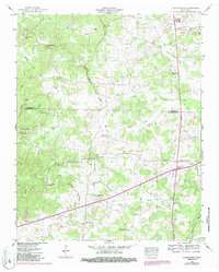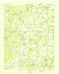
1936 Map of Clarksburg
USGS Topo · Published 1936About this map
Clarksburg and Parker Crossroads anchor this 1936 survey of the West Tennessee interior, a landscape defined by its network of churches and rural schools. The Center Ridge Basin Divide separates the Rutherford Fork Obion River system from the headwaters of the Big Sandy River, influencing the placement of early settlements and family landmarks. This map captures a strictly agrarian era where social life centered on institutions like the Hickory Plains Ch, Rock Spring Sch, and Parker Chapel. Genealogists will find significant value in the detailed placement of burial grounds such as Hart Cem, Pearson Cem, and Roan Creek Cem. The transition from natural drainage to managed waterways is visible in the east, where a Drainage Ditch runs parallel to State Highway No 22 near Mt Ararat Spring.
Find a feature on this map
57 named features on this map. Tap any name to fly to it.
Don’t see what you’re looking for? This feature index may not catch every label — zoom into the map to look around manually.
Map Details
Editions of this 1936 Clarksburg Map
This is the sole edition of this map. No revisions or reprints were ever made.
Historical Maps of Clarksburg Through Time
7 maps found