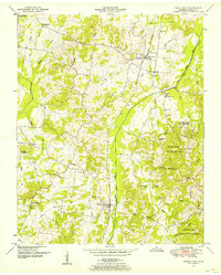
1950 Map of Buena Vista
USGS Topo · Published 1953About this map
The Tennessee Valley Divide cuts through this landscape, dictating the flow of numerous waterways toward the Big Sandy River Drainage Canal. In the mid-twentieth century, the Nashville Chattanooga and St Louis railroad served as a central transport corridor, passing through the settlements of Buena Vista and Westport. This era shows a community deeply tied to its local institutions, evidenced by the high density of small churches and schools such as Spanish Grove School and Oak Grove Church. Large portions of the eastern terrain are dedicated to the Natchez Trace State Park and Forest, where the landscape transitions into swampy lowlands like Goose Pond Swamp and Bradford Swamp. For genealogists, the map is a primary source for locating family burials at sites like Cawthon Cem, Spellings Cem, and Tucker Cem.
Find a feature on this map
56 named features on this map. Tap any name to fly to it.
Don’t see what you’re looking for? This feature index may not catch every label — zoom into the map to look around manually.
Map Details
Editions of this 1950 Buena Vista Map
3 editions found
Other maps of this area

1936 · Clarksburg
USGS Topo · 1:24,000

1936 · Yuma
USGS Topo · 1:24,000

1936 · Seventeen Creek
USGS Topo · 1:24,000

1936 · Vale
USGS Topo · 1:24,000

1936 · Center Ridge
USGS Topo · 1:24,000

1936 · Bruceton
USGS Topo · 1:24,000

1936 · Cavvia
USGS Topo · 1:24,000

1936 · Buena Vista
USGS Topo · 1:24,000

1950 · Yuma
USGS Topo · 1:24,000

1950 · Palmer Shelter
USGS Topo · 1:24,000