1930s Maps of Erin, Tennessee
Explore 2 historic maps of Erin from the 1930s. These maps offer a rare glimpse into what life looked like during the 1930s — showing old roads, neighborhoods, homes, and landmarks that have changed or disappeared over time.
Whether you're researching your family's past, planning a metal detecting trip, or studying how Erin's landscape evolved across the 1930s, these high-resolution maps are a powerful tool for exploring the history of this region.
- Focus on a specific era: All maps on this page are from the 1930s, giving you a focused view of this time period.
- See what’s changed: Compare century-old streets, trails, and buildings to today's modern landscape using overlays and satellite layers.
- Research with precision: Use these maps for genealogy, historical research, land use analysis, or educational projects.
- View, download, or print: Maps are fully viewable online in high resolution, and can be downloaded or printed for your own records.
Start exploring Erin's history through authentic maps from the 1930s. This is your window into the past.
Erin, TN maps
(2)- 1931 Map of Erin
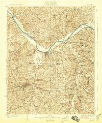 1931 Erin1931 Print · USGSThe Cumberland River corridor and the railroad hub of Erin define this landscape in the late 1920s. Genealogists can trace family footprints through dozens of rural schools and churches, from Blooming Grove Ch to the remote Cave Orchard Sch.
 - 1936 Map of Tantrough Hollow
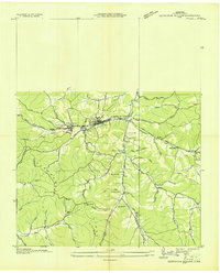 1936 Tantrough Hollow1936 Print · USGSHouston County at the height of the mid-1930s reveals a landscape of limestone industry and ridge-top settlements. Genealogists can trace family names across Lockhart Cem, locate the Cedar Valley Ch, or find vanished school sites like Bateman Sch.
End of results
Showing maps 1-2 of 2
Top cities near Erin
- Clarksville historical maps
- Waverly historical maps
- Camden historical maps
- Dover historical maps
- Cumberland City historical maps
- Slayden historical maps
Top neighborhoods of Erin
Frequently asked questions
- What are the different types of historical maps available for Erin?
- What is the oldest map of Erin?
- Where can I purchase historical maps of Erin for my home or office?
- Where can I download high-res historical maps of Erin?
- Are there historical topographic maps available for Erin?
- Is there historical aerial imagery available for Erin?
- Where are historical maps of Erin sourced from?