1930s Maps of McEwen, Tennessee
Explore 4 historic maps of McEwen from the 1930s. These maps offer a rare glimpse into what life looked like during the 1930s — showing old roads, neighborhoods, homes, and landmarks that have changed or disappeared over time.
Whether you're researching your family's past, planning a metal detecting trip, or studying how McEwen's landscape evolved across the 1930s, these high-resolution maps are a powerful tool for exploring the history of this region.
- Focus on a specific era: All maps on this page are from the 1930s, giving you a focused view of this time period.
- See what’s changed: Compare century-old streets, trails, and buildings to today's modern landscape using overlays and satellite layers.
- Research with precision: Use these maps for genealogy, historical research, land use analysis, or educational projects.
- View, download, or print: Maps are fully viewable online in high resolution, and can be downloaded or printed for your own records.
Start exploring McEwen's history through authentic maps from the 1930s. This is your window into the past.
McEwen, TN maps
(4)- 1936 Map of Gorman
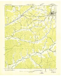 1936 Gorman1936 Print · USGSHumphreys County appears in transition during the mid-1930s as modern power lines and rail networks began to reshape this rural landscape. Genealogists and researchers can trace family landmarks and community centers like Bennyfield Cem, Bethel Ch, and Wallace Sch.
 - 1936 Map of Woolworth
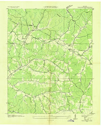 1936 Woolworth1936 Print · USGSThe borderlands of Humphreys and Houston counties are captured here in the mid-1930s as the Tennessee Valley Authority began its regional surveys. Researchers can trace rural life through numerous local landmarks, such as Woolworth Sch, Curtis Chapel, and Batson Cem.
 - 1936 Map of Ruskin
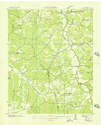 1936 Ruskin1936 Print · USGSMid-Tennessee's highland rim is captured here in the mid-1930s, showing the intersection of Dickson, Houston, and Humphreys counties. Local researchers can trace family lands near Cave Ruskin, find old rural schoolhouses like Olivet Sch, and locate family burial grounds including Dotson Cem.
 - 1936 Map of Tennessee City
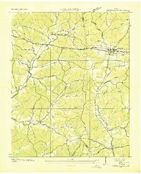 1936 Tennessee City1936 Print · USGSThe Humphreys and Dickson County borderlands were undergoing a period of rapid modernization in the mid-1930s as electricity and highways expanded across the hills. Researchers can trace rural life through landmarks like Fiftyfour, Fewville, and several country schools including Holland Sch.
End of results
Showing maps 1-4 of 4
Top cities near McEwen
- Dickson historical maps
- Waverly historical maps
- Erin historical maps
- Vanleer historical maps
- Slayden historical maps
Frequently asked questions
- What are the different types of historical maps available for McEwen?
- What is the oldest map of McEwen?
- Where can I purchase historical maps of McEwen for my home or office?
- Where can I download high-res historical maps of McEwen?
- Are there historical topographic maps available for McEwen?
- Is there historical aerial imagery available for McEwen?
- Where are historical maps of McEwen sourced from?