Old Maps of Jefferson County, Tennessee for Metal Detecting
Plan your next treasure hunt with 130 historic maps of Jefferson County. Find old homesites, ghost towns, trails, and gathering spots that may be lost to time — perfect for identifying promising metal detecting locations.
- Locate forgotten sites: Uncover places like long-lost settlements, abandoned rail lines, or gathering spots.
- Plan better hunts: Use map overlays combined with LiDAR or satellite views to narrow in on historically rich areas.
- Made for detectorists: Thousands of hobbyists use these maps to discover relics, coins, and hidden history.
Use these historic maps to boost your research and find new opportunities beneath the surface of Jefferson County.
Jefferson County, TN maps
(130)- 1883 Map of Morristown
 1883 Morristown1883 Print · USGSEast Tennessee in the 1880s is defined by the convergence of mountain ridges and the vital rail corridor through Morristown. Researchers can trace the early industrial landscape of the region through landmarks like Witt's Foundry, Tate's Springs, and the historic Bean's Station.
 - 1886 Map of Knoxville
 1886 Knoxville1886 Print · USGSEast Tennessee in the late nineteenth century was a landscape of river ferries and mountain coves centered around the growing hub of Knoxville. Genealogists can locate family landmarks like Spencer Cabin, Montvale Springs, and the old Brabsons Ferry river crossing.
 - 1892 Map of Knoxville
 1892 Knoxville1892 Print · USGSEastern Tennessee in the late nineteenth century shows a landscape of river-valley commerce transitioning into the Great Smokies. Genealogists can trace early homesteads near Sevierville or locate landmarks like Porter Academy and Boyd Ferry.
 - 1893 Map of Mt Guyot
 1893 Mt Guyot1893 Print · USGSThe Tennessee and North Carolina borderlands are captured here in the 1890s, when isolated mountain coves and river towns relied on the Virginia and Georgia Railroad. Researchers can trace old family sites and transport routes through Fair Garden, Jones Cove, and along the Elliot Ferry Road.3 unique versions available
 - 1893 Map of Morristown
 1893 Morristown1893 Print · USGSEast Tennessee in the 1890s was a landscape of deep mountain ridges and vital rail junctions centered around Morristown. Researchers can trace the nineteenth-century river economy through numerous crossings like Cloud Ferry and find early industry at Lotspeachy Mill.
 - 1894 Map of Knoxville
 1894 Knoxville1894 Print · USGSThe Tennessee valley meets the high Smokies in the 1890s, revealing a landscape of river ferries, mountain coves, and emerging rail towns. Genealogists and historians can trace early crossings at Boyd Ferry, established schools like Porter Academy, and the early footprints of Gatlinburg and Pigeon Forge.
 - 1895 Map of Morristown
 1895 Morristown1895 Print · USGSThe East Tennessee ridge-and-valley country comes alive in the late nineteenth century as a hub of rail and river transit. Trace the routes of old Evans Ferry or locate vanished stops along the Southern R.R. near Morristown and Bull Gap.5 unique versions available
 - 1895 Map of Knoxville
 1895 Knoxville1895 Print · USGSThe Tennessee and French Broad Rivers converge in this late-nineteenth-century survey of East Tennessee’s rising landscape. Trace the early rail lines and mountain crossings that shaped life for families in Sevierville, Gatlinburg, and Maryville.2 unique versions available
 - 1897 Map of Maynardville
 1897 Maynardville1897 Print · USGSEast Tennessee in the late nineteenth century was a landscape of high ridges and vital river fords. Genealogists and historians can trace old homesteads and transit hubs like Nances Ferry, the Lead Mine at New Prospect, and Massongills Mill.
 - 1900 Map of Maynardville
 1900 Maynardville1900 Print · USGSEast Tennessee was a world of river fords and mountain gaps at the turn of the century, dominated by the winding Clinch and Powell rivers. Genealogists can trace family roots through specific landmarks like Massongills Mill, Church Grove, and Sharps Chapel.4 unique versions available
 - 1901 Map of Knoxville
 1901 Knoxville1901 Print · USGSThe East Tennessee borderlands meet the high Smokies at the turn of the century. Genealogists can trace early homesteads and crossroads near Sevierville and Maryville, or find landmarks like Cade Cove and Gatlinburg before they became tourist hubs.5 unique versions available
 - 1912 Map of Mt Guyot
 1912 Mt Guyot1912 Print · USGSThe Tennessee and North Carolina borderlands come into focus in the early twentieth century, prior to the creation of the Great Smoky Mountains National Park. Trace ancestral locations like Cataloochee and Smokemont or follow the Southern RR to Newport.5 unique versions available
 - 1935 Map of White Pine
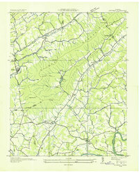
 1935 White Pine1935 Print · USGSThe Jefferson County countryside around White Pine is shown here in the mid-1930s as the French Broad River valley hummed with rural industry. Researchers can trace family-named landmarks like Anderson Mill, Hawkins Chapel, and Westminster Cem.
 - 1935 Map of Luttrell
 1935 Luttrell1935 Print · USGSRichland Valley and the surrounding ridges are captured in the mid-1930s as the river-and-rail economy thrived. Genealogists can trace family names through landmarks like Nances Ferry, Rush Strong Sch, and McKinney Cem.
 - 1935 Map of Mascot
 1935 Mascot1935 Print · USGSEast Tennessee during the mid-thirties reveals a landscape of river-bend farms and developing transit corridors along the Holston River. Genealogists and historians can trace family locations near Smith Mill, Howell Cem, and rural schoolhouses like Cynthiana Sch.
 - 1935 Map of English Mountain
 1935 English Mountain1935 Print · USGSSevier County and the foothills of the Smokies are seen here during the mid-thirties as the national park was taking shape. Genealogists can trace family roots through scores of rural institutions like Smoky Mtn Academy, Pittman Center, and the Crockettville Sch.
 - 1935 Map of Straw Plains
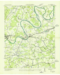
 1935 Straw Plains1935 Print · USGSEast Tennessee life in the mid-1930s is centered on the winding Holston River and the bustling Southern railroad corridor. Researchers can trace family roots at Hickle Cem, find the site of Massengale Mill, or locate Indian Cave.
 - 1935 Map of Clevenger
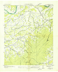 1935 Clevenger1935 Print · USGSJefferson and Cocke Counties are shown in the mid-1930s, featuring the rural communities nestled against the slopes of English Mountain. Genealogists and historians can locate family landmarks like Bridges Ch, trace the site of CCC Camp No 1467, or find the old Blowing Cave Mill.
 - 1935 Map of Joppa
 1935 Joppa1935 Print · USGSThe rural Holston River valley comes to life in the mid-1930s, showing a landscape defined by family-named stores and river crossings. Genealogists and historians can trace local life through sites like Indian Cave Ferry, Haworth Cem, and CCC Camp No 8.
 - 1935 Map of Morristown
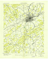 1935 Morristown1935 Print · USGSMorristown and its surrounding Tennessee countryside appear here during the mid-1930s as the regional rail and road networks were expanding. Researchers can trace family roots through sites like EMMA JARNAGAN CEM, Reed Chapel, and the CCC Camp No 1467.
 - 1935 Map of Shady Grove
 1935 Shady Grove1935 Print · USGSThe French Broad River valley at the border of Jefferson and Sevier counties is documented here just as the Tennessee Valley Authority began its regional work. Researchers can locate Depression-era rural landmarks like Lee Academy, Island Ford Mill, and Roaring Spring.
 - 1935 Map of New Market
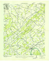
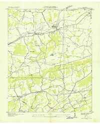 1935 New Market1935 Print · USGSJefferson County was undergoing significant modernization in the mid-1930s as the Tennessee Valley Authority mapped its growing infrastructure. Researchers can trace old family sites and industrial history through Dinwoody Mill, the SOUTHERN rail stops at Friends Station, and the Shrader Chapel Sch.
 - 1935 Map of Jefferson City
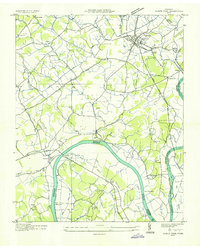
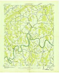
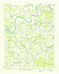
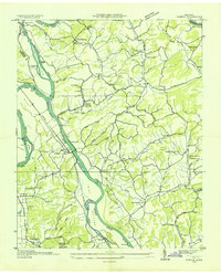
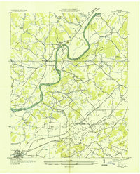
 1935 Jefferson City1935 Print · USGSJefferson County in the mid-1930s shows a landscape of river-valley farming and mountain ridges before major Tennessee Valley Authority changes. Genealogists can trace family landmarks like Wesley Chapel, Grants Chapel, and the Cedar Ridge Sch along the French Broad River.
 - 1935 Map of Rankin
 1935 Rankin1935 Print · USGSIn the mid-1930s, the river valleys of East Tennessee were still defined by small farming communities and country schools. Genealogists can trace family footprints at Atchleys Mill, Rorex Chapel, and the community of Rankin along the Southern railroad.
 - 1935 Map of Talbott
 1935 Talbott1935 Print · USGSThe rural river valley at the borders of Hamblen and Jefferson counties comes to life in this mid-1930s survey. Genealogists can locate family landmarks like the Martha Sunderland Cem, Wilson Cager Sch, and old river sites like Collins Ford.
Showing maps 1-25 of 130
Top cities of Jefferson County
- Jefferson City historical maps
- Dandridge historical maps
- Strawberry Plains historical maps
- White Pine historical maps
- New Market historical maps
- Baneberry historical maps
Frequently asked questions
- What are the different types of historical maps available for Jefferson County?
- What is the oldest map of Jefferson County?
- Where can I purchase historical maps of Jefferson County for my home or office?
- Where can I download high-res historical maps of Jefferson County?
- Are there historical topographic maps available for Jefferson County?
- Is there historical aerial imagery available for Jefferson County?
- Where are historical maps of Jefferson County sourced from?