1930s Maps of Moore Road, Knoxville
Explore 2 historic maps of Moore Road from the 1930s. These maps offer a rare glimpse into what life looked like during the 1930s — showing old roads, neighborhoods, homes, and landmarks that have changed or disappeared over time.
Whether you're researching your family's past, planning a metal detecting trip, or studying how Moore Road's landscape evolved across the 1930s, these high-resolution maps are a powerful tool for exploring the history of this region.
- Focus on a specific era: All maps on this page are from the 1930s, giving you a focused view of this time period.
- See what’s changed: Compare century-old streets, trails, and buildings to today's modern landscape using overlays and satellite layers.
- Research with precision: Use these maps for genealogy, historical research, land use analysis, or educational projects.
- View, download, or print: Maps are fully viewable online in high resolution, and can be downloaded or printed for your own records.
Start exploring Moore Road's history through authentic maps from the 1930s. This is your window into the past.
Moore Road, Knoxville maps
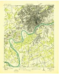
(2)- 1935 Map of Knoxville
 1935 Knoxville1935 Print · USGSKnoxville and its southern Blount County neighbors appear here in the mid-1930s as the TVA era begins. Researchers can trace family roots through Mt Olive Cem, locate the old Eastern State Hospital, or study the early layout of Sequoyah Hills.
 - 1936 Map of Knoxville
 1936 Knoxville1936 Print · USGSKnoxville and its riverfront suburbs come alive in this mid-1930s survey, showing the city just as the TVA began its regional work. Genealogists and historians can locate family homes near Knoxville College, the State School for Deaf, or old cemeteries like New Gray Cem.
End of results
Showing maps 1-2 of 2
Top cities near Moore Road
- Knoxville historical maps
- Maryville historical maps
- Powell historical maps
- Halls Crossroads historical maps
- Clinton historical maps
- Alcoa historical maps
See more
Frequently asked questions
- What are the different types of historical maps available for Moore Road?
- What is the oldest map of Moore Road?
- Where can I purchase historical maps of Moore Road for my home or office?
- Where can I download high-res historical maps of Moore Road?
- Are there historical topographic maps available for Moore Road?
- Is there historical aerial imagery available for Moore Road?
- Where are historical maps of Moore Road sourced from?