2020s Maps of Loudon County, Tennessee
Explore 12 historic maps of Loudon County from the 2020s. These maps offer a rare glimpse into what life looked like during the 2020s — showing old roads, neighborhoods, homes, and landmarks that have changed or disappeared over time.
Whether you're researching your family's past, planning a metal detecting trip, or studying how Loudon County's landscape evolved across the 2020s, these high-resolution maps are a powerful tool for exploring the history of this region.
- Focus on a specific era: All maps on this page are from the 2020s, giving you a focused view of this time period.
- See what’s changed: Compare century-old streets, trails, and buildings to today's modern landscape using overlays and satellite layers.
- Research with precision: Use these maps for genealogy, historical research, land use analysis, or educational projects.
- View, download, or print: Maps are fully viewable online in high resolution, and can be downloaded or printed for your own records.
Start exploring Loudon County's history through authentic maps from the 2020s. This is your window into the past.
Loudon County, TN maps
(12)- 2022 Map of Meadow, 2022 Print
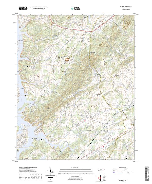 2022 Meadow2022 Print · USGSLoudon and Blount counties are depicted here in the early 2020s, showing the interaction between the Little Tennessee River and longstanding rural communities. Genealogists can trace numerous family burial sites such as Morganton Cem and Cloyds Creek Cem near Greenback and Friendsville.
 - 2022 Map of Loudon, 2022 Print
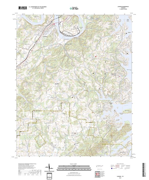 2022 Loudon2022 Print · USGSLoudon and the Tennessee River valley are documented here in recent years, showing a landscape defined by expansive lakes and deep-rooted settlements. Genealogists can trace family names through several historic sites like Davis Cem, Eve Mills, and Burton Mill.
 - 2022 Map of Pattie Gap, 2022 Print
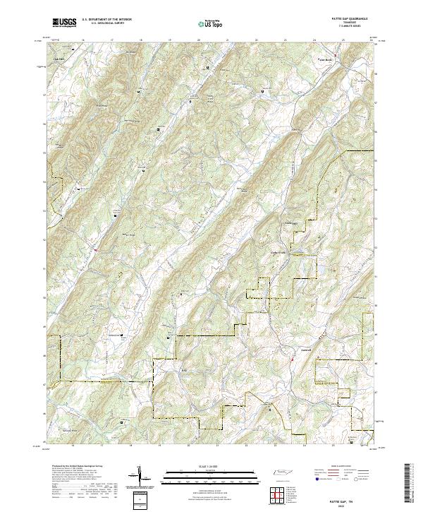 2022 Pattie Gap2022 Print · USGSThe convergence of four East Tennessee counties comes to life in this recent survey of the ridges and valleys near the Tennessee River. Genealogists and local historians can trace family land near Cook Mill, Blue Spring Ch, and numerous burial sites like Galyon Cem.
 - 2022 Map of Philadelphia, 2022 Print
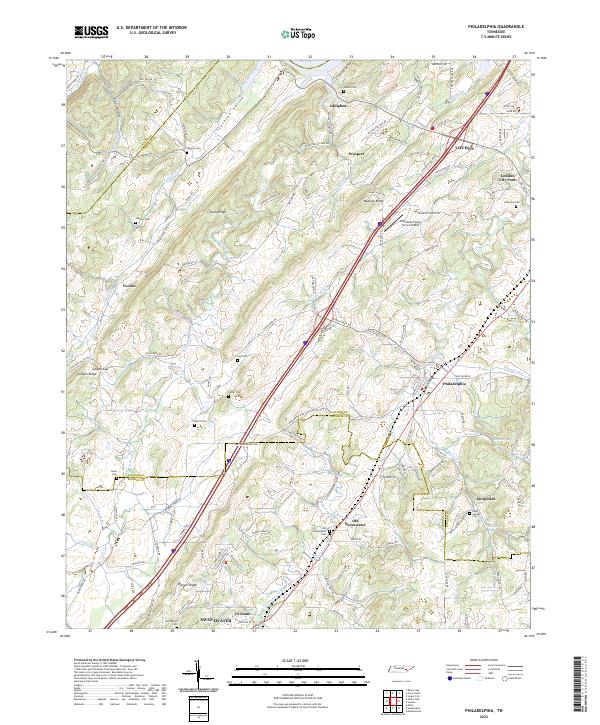 2022 Philadelphia2022 Print · USGSPhiladelphia and the Tennessee Valley ridges come into focus on this modern survey of the Loudon and Monroe county borders. Genealogists can locate numerous family burial sites like Wilson Cem and Lay Cem or trace the early paths along Pond Creek.
 - 2022 Map of Lenoir City, 2022 Print
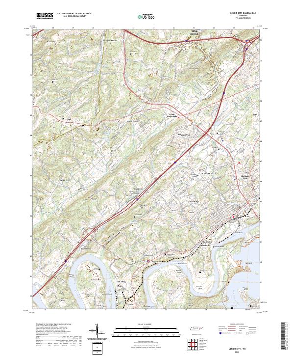 2022 Lenoir City2022 Print · USGSNear the confluence of the Tennessee and Little Tennessee Rivers, this modern survey shows the evolved landscape of Lenoir City and Loudon. Researchers can trace local heritage through sites like Oral Cem, Bussell Island, and the historical bends at Huff Ferry Bend.
 - 2022 Map of Cave Creek, 2022 Print
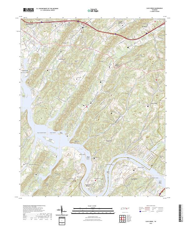 2022 Cave Creek2022 Print · USGSThe Tennessee River valley south of Kingston appears in this recent survey, showing the complex interplay of ridges and river bends. Genealogists can trace family names at Bradbury Cemetery, Johnston Cemetery, and the Wolf Creek Airport.
 - 2022 Map of Concord, 2022 Print
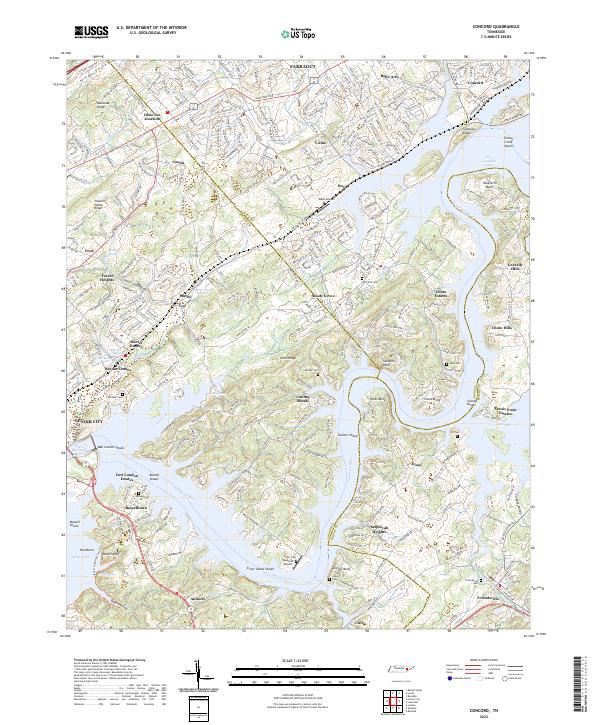 2022 Concord2022 Print · USGSThe Tennessee River valley south of Farragut comes alive here in the early twenty-first century, showing the intersection of historic river settlements and modern lakeside growth. Researchers can trace family roots at Friendsville Cem, locate the site of Busselltown, or explore the geography of Saltpeter Bluff and Sister Island Shoals.
 - 2022 Map of Bethel Valley, 2022 Print
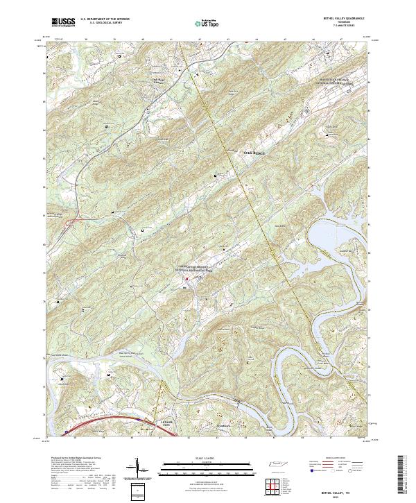 2022 Bethel Valley2022 Print · USGSEastern Tennessee at the edge of the atomic age is revealed here, where high-security federal history overlaps with old valley settlements. Genealogists can trace family landmarks like Douglas Chapel Cem and Gravel Hill Cem near the winding Clinch River.
 - 2022 Map of Lovell, 2022 Print
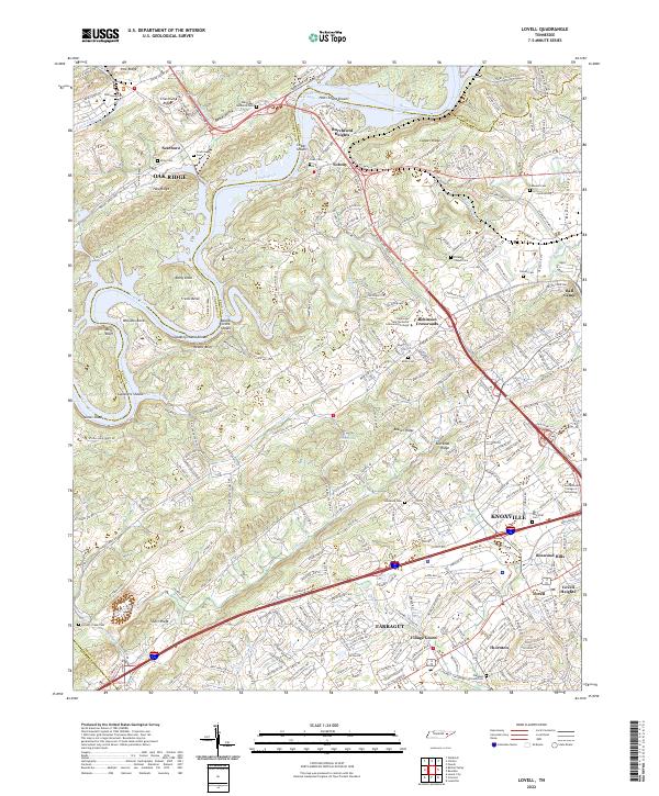 2022 Lovell2022 Print · USGSWestern Knox County appears here in the early twenty-first century, showing the transition from the ridges of Oak Ridge to the growing suburbs of Farragut. Researchers can locate several historic family and community burial grounds like Scarborough and Estes Cem, alongside old crossroads like Solway.
 - 2022 Map of Vonore, 2022 Print
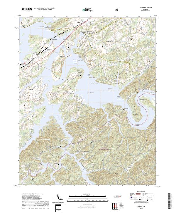 2022 Vonore2022 Print · USGSThe Little Tennessee River valley near the Monroe and Loudon county lines is captured here in the contemporary era. Researchers can locate numerous family burial sites like Niles-McGhee Cem and Hardin Cem, or trace the grounds of Fort Loudon and Shaddon Mill.
 - 2022 Map of Niota, 2022 Print
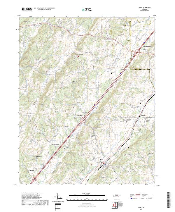 2022 Niota2022 Print · USGSThe rural valleys and ridges of McMinn County are shown here in detail during the early 2020s. Genealogists can locate numerous small burial grounds and landmarks like Union McMinn Baptist Church Cem, Acme Mill, and Riddles Store.
 - 2023 Map of Madisonville, 2023 Print
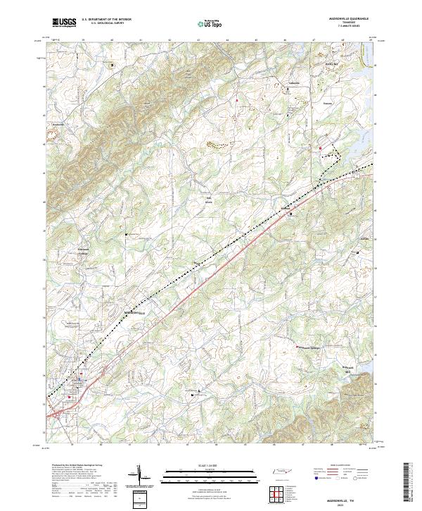 2023 Madisonville2023 Print · USGSThe Monroe County seat and the campus of Hiwassee College appear here in the early twenty-first century. Genealogists can locate family landmarks like Stephens Cem, Kimbrough Cem, and the historic Hopewell Mill on Notchy Creek.
End of results
Showing maps 1-12 of 12
Top cities of Loudon County
- Lenoir City historical maps
- Tellico Village historical maps
- Loudon historical maps
- Greenback historical maps
- Philadelphia historical maps
Frequently asked questions
- What are the different types of historical maps available for Loudon County?
- What is the oldest map of Loudon County?
- Where can I purchase historical maps of Loudon County for my home or office?
- Where can I download high-res historical maps of Loudon County?
- Are there historical topographic maps available for Loudon County?
- Is there historical aerial imagery available for Loudon County?
- Where are historical maps of Loudon County sourced from?