1940s Maps of Greenback, Tennessee
Explore 3 historic maps of Greenback from the 1940s. These maps offer a rare glimpse into what life looked like during the 1940s — showing old roads, neighborhoods, homes, and landmarks that have changed or disappeared over time.
Whether you're researching your family's past, planning a metal detecting trip, or studying how Greenback's landscape evolved across the 1940s, these high-resolution maps are a powerful tool for exploring the history of this region.
- Focus on a specific era: All maps on this page are from the 1940s, giving you a focused view of this time period.
- See what’s changed: Compare century-old streets, trails, and buildings to today's modern landscape using overlays and satellite layers.
- Research with precision: Use these maps for genealogy, historical research, land use analysis, or educational projects.
- View, download, or print: Maps are fully viewable online in high resolution, and can be downloaded or printed for your own records.
Start exploring Greenback's history through authentic maps from the 1940s. This is your window into the past.
Greenback, TN maps
(3)- 1940 Map of Meadow
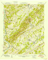 1940 Meadow1940 Print · USGSLoudon and Blount Counties appear here in the early 1940s, just as the local river-and-rail economy defined daily life. Genealogists and researchers can trace historic river crossings like Morganton Ferry or find rural landmarks like Axley Chapel and Greenback.
 - 1941 Map of Vonore, 1960 Print
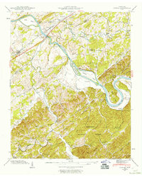 1941 Vonore1960 Print · USGSThe Little Tennessee River valley comes alive in the early 1940s, showing a landscape of ferry crossings and river islands before modern flooding. Researchers can trace family roots through Toqua Sch, Bacon Ferry, and landmarks like Fort Loudon.5 unique versions available
 - 1942 Map of Vonore
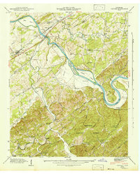 1942 Vonore1942 Print · USGSMonroe County's river valleys are shown here in the early 1940s, just as the Tennessee Valley Authority was reshaping the region's waters. Genealogists can trace family footprints at Shaddon Mill, Montgomery Cem, and the old river crossing at Bacon Ferry.
End of results
Showing maps 1-3 of 3
Top cities near Greenback
- Knoxville historical maps
- Maryville historical maps
- Farragut historical maps
- Alcoa historical maps
- Lenoir City historical maps
- Tellico Village historical maps
See more
Top neighborhoods of Greenback
Frequently asked questions
- What are the different types of historical maps available for Greenback?
- What is the oldest map of Greenback?
- Where can I purchase historical maps of Greenback for my home or office?
- Where can I download high-res historical maps of Greenback?
- Are there historical topographic maps available for Greenback?
- Is there historical aerial imagery available for Greenback?
- Where are historical maps of Greenback sourced from?