1930s Maps of Bethel Springs, Tennessee
Explore 2 historic maps of Bethel Springs from the 1930s. These maps offer a rare glimpse into what life looked like during the 1930s — showing old roads, neighborhoods, homes, and landmarks that have changed or disappeared over time.
Whether you're researching your family's past, planning a metal detecting trip, or studying how Bethel Springs's landscape evolved across the 1930s, these high-resolution maps are a powerful tool for exploring the history of this region.
- Focus on a specific era: All maps on this page are from the 1930s, giving you a focused view of this time period.
- See what’s changed: Compare century-old streets, trails, and buildings to today's modern landscape using overlays and satellite layers.
- Research with precision: Use these maps for genealogy, historical research, land use analysis, or educational projects.
- View, download, or print: Maps are fully viewable online in high resolution, and can be downloaded or printed for your own records.
Start exploring Bethel Springs's history through authentic maps from the 1930s. This is your window into the past.
Bethel Springs, TN maps
(2)- 1936 Map of Purdy
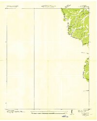 1936 Purdy1936 Print · USGSMcNairy County during the mid-thirties is documented here as the Tennessee Valley Authority began mapping the region's drainage and road networks. Researchers can trace the early path of Highway 64 and the settlement of Purdy along the Tennessee Basin Divide.
 - 1936 Map of Mt. Peter
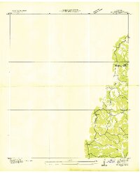 1936 Mt. Peter1936 Print · USGSMcNairy County was undergoing significant modernization in the mid-1930s as federal power projects reached rural Tennessee. Genealogists can trace family footprints near Beauty Hill Ch, Mackey Sch, and the local Cem at Mt Peter.
End of results
Showing maps 1-2 of 2
Top cities near Bethel Springs
- Henderson historical maps
- Selmer historical maps
- Adamsville historical maps
- Michie historical maps
- Eastview historical maps
- Guys historical maps
See more
Frequently asked questions
- What are the different types of historical maps available for Bethel Springs?
- What is the oldest map of Bethel Springs?
- Where can I purchase historical maps of Bethel Springs for my home or office?
- Where can I download high-res historical maps of Bethel Springs?
- Are there historical topographic maps available for Bethel Springs?
- Is there historical aerial imagery available for Bethel Springs?
- Where are historical maps of Bethel Springs sourced from?