1940s Maps of Moore County, Tennessee
Explore 10 historic maps of Moore County from the 1940s. These maps offer a rare glimpse into what life looked like during the 1940s — showing old roads, neighborhoods, homes, and landmarks that have changed or disappeared over time.
Whether you're researching your family's past, planning a metal detecting trip, or studying how Moore County's landscape evolved across the 1940s, these high-resolution maps are a powerful tool for exploring the history of this region.
- Focus on a specific era: All maps on this page are from the 1940s, giving you a focused view of this time period.
- See what’s changed: Compare century-old streets, trails, and buildings to today's modern landscape using overlays and satellite layers.
- Research with precision: Use these maps for genealogy, historical research, land use analysis, or educational projects.
- View, download, or print: Maps are fully viewable online in high resolution, and can be downloaded or printed for your own records.
Start exploring Moore County's history through authentic maps from the 1940s. This is your window into the past.
Moore County, TN maps
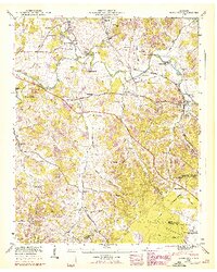
(10)- 1941 Map of Cumberland Springs, 1943 Print
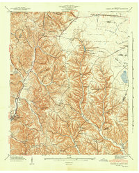 1941 Cumberland Springs1943 Print · USGSMoore County and the Highland Rim are captured in the early 1940s, just as the nearby military expansion began to transform the local landscape. Genealogists can trace family footprints through community sites like Lynchburg, Bakertown, and Hickory Hill Sch.5 unique versions available
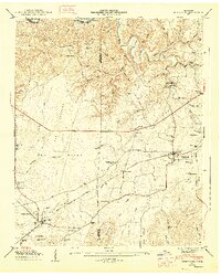
 - 1941 Map of Camp Forrest, 1943 Print
 1941 Camp Forrest1943 Print · USGSThe Tennessee mobilization of the early 1940s is on full display as the Camp Forrest Military Reservation rises near Tullahoma. Genealogists and historians can trace family-named sites like Holt Cem and Pylant Springs before the landscape was fully altered by military expansion.2 unique versions available
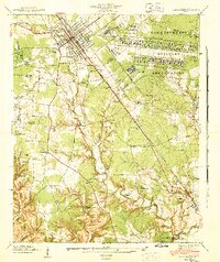
 - 1943 Map of Mc Minnville, 1944 Print
 1943 Mc Minnville1944 Print · USGSMid-Tennessee is captured here during the mobilization of the early 1940s, showing the vast Camp Forrest Military Reservation and thriving rail towns. Trace the N C & ST L line through Mcminnville or locate smaller rural hubs like Morrison and Hickerson Station.
 - 1944 Map of Shelbyville
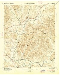
 1944 Shelbyville1944 Print · USGSMid-century Middle Tennessee is captured here during the wartime mobilization of the 1940s. Genealogists and researchers can trace family lands near Bugscuffle, Shelbyville Mills, and the expansive Camp Forrest Military Res.
 - 1947 Map of Mulberry, 1948 Print
 1947 Mulberry1948 Print · USGSLincoln County and Moore County communities thrive along the Elk River and its tributaries during the late 1940s. Genealogists and historians can trace family homesteads through over a dozen named burial sites like Renegar Cem, find landmarks like Lockes Mill, and locate the Moore Chapel Sch.3 unique versions available
 - 1947 Map of Lois, 1948 Print
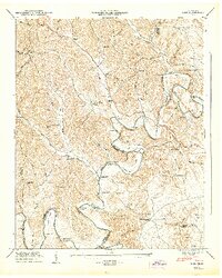 1947 Lois1948 Print · USGSMoore and Franklin counties are shown here just after the war, where the ELK RIVER winds through a landscape of family-named ridges and hollows. Researchers can trace old homesteads and community anchors like Lois, Brandon Chapel, and the Sylvania Sch.2 unique versions available
 - 1947 Map of Normandy, 1948 Print
 1947 Normandy1948 Print · USGSBedford and Moore Counties are captured here shortly after the war, when the Duck River still powered local industry. Genealogists can trace family names across Cortner Cem and Ledfords Mill or locate rural landmarks like Shoffner Ch.7 unique versions available
 - 1947 Map of Huntland, 1948 Print
 1947 Huntland1948 Print · USGSFranklin and Lincoln County life in the late 1940s centers on the rail corridor and river bends south of the Elk River. Local historians can trace family roots through sites like Falls Mill, Simmons Chapel, and numerous family burial grounds including Mc Clure Cem.4 unique versions available
 - 1949 Map of Belleville, 1974 Print
 1949 Belleville1974 Print · USGSLincoln County was a landscape of high ridges and deep hollows in the years following the war, centered around the community of Belleville. Researchers can trace old family burial grounds and country parishes like Hickory Hill Church and Wylie Cemetery.2 unique versions available
 - 1949 Map of Booneville, 1974 Print
 1949 Booneville1974 Print · USGSMoore County and the surrounding ridges come to life in this mid-century survey of the region around the Lynchburg distillery country. Genealogists can trace family footprints across dozens of named hollows and remote burial sites like Shoffner Cem and Cox Cem.2 unique versions available
End of results
Showing maps 1-10 of 10
Frequently asked questions
- What are the different types of historical maps available for Moore County?
- What is the oldest map of Moore County?
- Where can I purchase historical maps of Moore County for my home or office?
- Where can I download high-res historical maps of Moore County?
- Are there historical topographic maps available for Moore County?
- Is there historical aerial imagery available for Moore County?
- Where are historical maps of Moore County sourced from?