1900s (20th Century) Maps of Lois, Lynchburg
Explore 5 historic maps of Lois from the 1900s (20th Century). These maps offer a rare glimpse into what life looked like during the 1900s — showing old roads, neighborhoods, homes, and landmarks that have changed or disappeared over time.
Whether you're researching your family's past, planning a metal detecting trip, or studying how Lois's landscape evolved across the 1900s, these high-resolution maps are a powerful tool for exploring the history of this region.
- Focus on a specific era: All maps on this page are from the 1900s, giving you a focused view of this time period.
- See what’s changed: Compare century-old streets, trails, and buildings to today's modern landscape using overlays and satellite layers.
- Research with precision: Use these maps for genealogy, historical research, land use analysis, or educational projects.
- View, download, or print: Maps are fully viewable online in high resolution, and can be downloaded or printed for your own records.
Start exploring Lois's history through authentic maps from the 1900s. This is your window into the past.
Lois, Lynchburg maps
(5)- 1936 Map of Lois
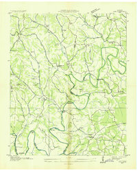 1936 Lois1936 Print · USGSMoore County at the start of the Tennessee Valley Authority era shows a landscape of river-bend farms and scattered crossroads settlements. Genealogists can locate family-named landmarks such as Gray Cem, Browningtown, and the Liberty Hill Sch along the Elk River.
 - 1947 Map of Lois, 1948 Print
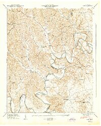 1947 Lois1948 Print · USGSMoore and Franklin counties are shown here just after the war, where the ELK RIVER winds through a landscape of family-named ridges and hollows. Researchers can trace old homesteads and community anchors like Lois, Brandon Chapel, and the Sylvania Sch.2 unique versions available
 - 1956 Map of Columbia, 1960 Print
 1956 Columbia1960 Print · USGSMiddle Tennessee in the mid-fifties presents a landscape of established river towns and critical rail hubs before the arrival of the modern interstate system. Researchers can trace the routes of the Louisville and Nashville railroad or locate historic landmarks like Stones River National Military Park and the Tennessee National Wildlife Refuge.6 unique versions available
 - 1972 Map of Lois, 1973 Print
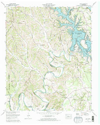 1972 Lois1973 Print · USGSMoore County and the Elk River valley entered a new era in the early seventies with the filling of the Tims Ford reservoir. Researchers can trace submerged landmarks and still-standing rural centers like Lois, Lexie Crossroads, and the Union Grove Ch.2 unique versions available
 - 1981 Map of Tullahoma, 1982 Print
 1981 Tullahoma1982 Print · USGSSouthern Tennessee enters the 1980s with a mix of aerospace technology and deep rural roots. Researchers can trace the L & N RR through Shelbyville and Fayetteville or locate family sites like Old Salem Cem and Blanton Chapel near the Cumberland Plateau.
End of results
Showing maps 1-5 of 5
Top cities near Lois
- Shelbyville historical maps
- Tullahoma historical maps
- Winchester historical maps
- Fayetteville historical maps
- Estill Springs historical maps
- Huntland historical maps
See more
Frequently asked questions
- What are the different types of historical maps available for Lois?
- What is the oldest map of Lois?
- Where can I purchase historical maps of Lois for my home or office?
- Where can I download high-res historical maps of Lois?
- Are there historical topographic maps available for Lois?
- Is there historical aerial imagery available for Lois?
- Where are historical maps of Lois sourced from?