1900s (20th Century) Maps of Sunbright, Tennessee
Explore 7 historic maps of Sunbright from the 1900s (20th Century). These maps offer a rare glimpse into what life looked like during the 1900s — showing old roads, neighborhoods, homes, and landmarks that have changed or disappeared over time.
Whether you're researching your family's past, planning a metal detecting trip, or studying how Sunbright's landscape evolved across the 1900s, these high-resolution maps are a powerful tool for exploring the history of this region.
- Focus on a specific era: All maps on this page are from the 1900s, giving you a focused view of this time period.
- See what’s changed: Compare century-old streets, trails, and buildings to today's modern landscape using overlays and satellite layers.
- Research with precision: Use these maps for genealogy, historical research, land use analysis, or educational projects.
- View, download, or print: Maps are fully viewable online in high resolution, and can be downloaded or printed for your own records.
Start exploring Sunbright's history through authentic maps from the 1900s. This is your window into the past.
Sunbright, TN maps
(7)- 1935 Map of Pilot Mountain
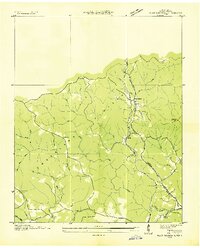 1935 Pilot Mountain1935 Print · USGSMorgan County’s high plateau country is captured here during the mid-1930s electrification era. Researchers can trace the families near Rome Ch, locate the Pilot Mtn Fire Tower, or follow the Southern rail line through Annadel.
 - 1946 Map of Pilot Mountain, 1947 Print
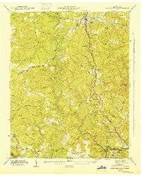 1946 Pilot Mountain1947 Print · USGSMorgan County in the mid-1940s reveals a landscape shaped by the Southern Railroad and early energy exploration. Researchers can trace family history at Stringfield Chapel, locate an Abandoned Tunnel, or find old burial sites like Hawn Cem.
 - 1952 Map of Rugby, 1953 Print
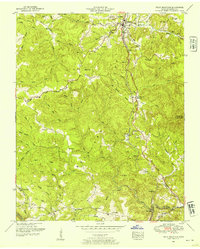
 1952 Rugby1953 Print · USGSThe Morgan and Scott County borderlands appear here in the early fifties as a landscape of timbered hills and railway towns. Researchers can trace family history through numerous burial sites like Rugby Cem and Webb Cem or follow the Southern Railway through Sixteen Tunnel.4 unique versions available
 - 1952 Map of Pilot Mountain, 1954 Print
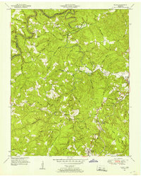
 1952 Pilot Mountain1954 Print · USGSMorgan County is shown in the early fifties as the railroad and small farming communities defined life on the Cumberland Plateau. Genealogists can trace family names at Hendren Cemetery, locate the old Abandoned tunnel, and explore rural centers like Sunbright and Annadel.3 unique versions available
 - 1956 Map of Corbin, 1966 Print
 1956 Corbin1966 Print · USGSThe Kentucky and Tennessee borderlands are captured here in the mid-fifties, showing the region's shift toward modern interstate travel and reservoir development. Genealogists and historians can trace old community lines near Albany and Monticello or locate early rail junctions along the Southern and Tennessee Central lines.3 unique versions available
 - 1958 Map of Corbin
 1958 Corbin1958 Print · USGSThe Upper Cumberland borderlands appear in the late 1950s as massive reservoirs and early atomic-era growth reshape the region. Trace family roots and vanished landmarks near Lake Cumberland, Oak Ridge, and the Cumberland National Forest.
 - 1979 Map of Oakridge, 1980 Print
 1979 Oakridge1980 Print · USGSThe eastern Tennessee highlands are captured here in the late 1970s, showcasing a landscape of coal mining and mountain conservation. Genealogists and researchers can locate family landmarks such as Potter Cem, Sunbright Sch, and the historic settlement of Rugby.
End of results
Showing maps 1-7 of 7
Top cities near Sunbright
- Fairfield Glade historical maps
- Oneida historical maps
- Huntsville historical maps
- Wartburg historical maps
- Allardt historical maps
Frequently asked questions
- What are the different types of historical maps available for Sunbright?
- What is the oldest map of Sunbright?
- Where can I purchase historical maps of Sunbright for my home or office?
- Where can I download high-res historical maps of Sunbright?
- Are there historical topographic maps available for Sunbright?
- Is there historical aerial imagery available for Sunbright?
- Where are historical maps of Sunbright sourced from?