1960s Maps of Pickett County, Tennessee
Explore 3 historic maps of Pickett County from the 1960s. These maps offer a rare glimpse into what life looked like during the 1960s — showing old roads, neighborhoods, homes, and landmarks that have changed or disappeared over time.
Whether you're researching your family's past, planning a metal detecting trip, or studying how Pickett County's landscape evolved across the 1960s, these high-resolution maps are a powerful tool for exploring the history of this region.
- Focus on a specific era: All maps on this page are from the 1960s, giving you a focused view of this time period.
- See what’s changed: Compare century-old streets, trails, and buildings to today's modern landscape using overlays and satellite layers.
- Research with precision: Use these maps for genealogy, historical research, land use analysis, or educational projects.
- View, download, or print: Maps are fully viewable online in high resolution, and can be downloaded or printed for your own records.
Start exploring Pickett County's history through authentic maps from the 1960s. This is your window into the past.
Pickett County, TN maps
(3)- 1962 Map of Moodyville, 1963 Print
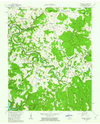 1962 Moodyville1963 Print · USGSThe Wolf River country along the Kentucky-Tennessee border appears here in the early sixties, showing a landscape of deep river bends and rural crossroads. Genealogists can locate dozens of family burial sites like Flowers Zachary Cem and Shadow Cem near settlements like Moodyville and Static.3 unique versions available
 - 1962 Map of Byrdstown, 1964 Print
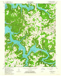 1962 Byrdstown1964 Print · USGSByrdstown and the surrounding river valleys are captured here in the early sixties, as the rising waters of Dale Hollow Reservoir transformed the landscape. Genealogists can trace family sites like the Cordell Hull Birthplace, Love Lady Cem, and the Ferry at Eagle Creek.4 unique versions available
 - 1968 Map of Dale Hollow Reservoir SE, 1971 Print
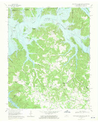 1968 Dale Hollow Reservoir SE1971 Print · USGSThe Kentucky-Tennessee borderlands appear here in the late sixties as the waters of Dale Hollow Reservoir reached their full extent. Genealogists can locate family landmarks like St John Cem, Maple Grove Sch, and the community of Taylors Crossroads.2 unique versions available
End of results
Showing maps 1-3 of 3
Top cities of Pickett County
Frequently asked questions
- What are the different types of historical maps available for Pickett County?
- What is the oldest map of Pickett County?
- Where can I purchase historical maps of Pickett County for my home or office?
- Where can I download high-res historical maps of Pickett County?
- Are there historical topographic maps available for Pickett County?
- Is there historical aerial imagery available for Pickett County?
- Where are historical maps of Pickett County sourced from?