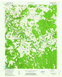
1962 Map of Moodyville
USGS Topo · Published 1963About this map
The Wolf River meanders deeply through the limestone-carved terrain of the Highland Rim along the Kentucky Tennessee border. In the early 1960s, this landscape was defined by its scattered rural communities like Moodyville, Chanute, and Byrdstown. The rising waters of the Dale Hollow Reservoir in the southwest corner reflect the mid-century transformation of the regional hydrology. For the local historian or genealogist, the map is remarkably dense with family burial grounds such as Flowers Zachary Cem, Amonette Cem, and Gilreath Mill Cem. Significant landmarks of the era include the Lookout Tower near Regan Knob and the Natural Bridge south of Sulphur Springs. Evidence of local industry and infrastructure is visible through the presence of a Strip Mine on Gorman Mtn, a Gaging Station on the river, and several Quarry sites dotting the hillsides.
Find a feature on this map
78 named features on this map. Tap any name to fly to it.
Don’t see what you’re looking for? This feature index may not catch every label — zoom into the map to look around manually.
Map Details
Editions of this 1962 Moodyville Map
3 editions found
Other maps of this area

1895 · Wartburg
USGS Topo · 1:125,000

1896 · Wartburg
USGS Topo · 1:125,000

1897 · Standingstone
USGS Topo · 1:125,000

1898 · Standingstone
USGS Topo · 1:125,000

1929 · Byrdstown
USGS Topo · 1:62,500

1934 · Pall Mall
USGS Topo · 1:62,500

1954 · Albany
USGS Topo · 1:24,000

1954 · Jamestown
USGS Topo · 1:24,000

1954 · Savage
USGS Topo · 1:24,000

1954 · Powersburg
USGS Topo · 1:24,000