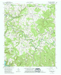
1962 Map of Moodyville
USGS Topo · Published 1976About this map
Wolf River snakes through the center of this terrain, its tight meanders carving deep valleys between prominent heights like Huddleston Knob and Regan Knob. The landscape is a patchwork of small upland settlements and family cemeteries that reflect the local genealogy of Pickett County. To the southwest, the rising waters of Dale Hollow Lake reach into the valleys, significantly altering the drainage patterns of Franklin Creek.
Find a feature on this map
75 named features on this map. Tap any name to fly to it.
Don’t see what you’re looking for? This feature index may not catch every label — zoom into the map to look around manually.
Map Details
Editions of this 1962 Moodyville Map
3 editions found
Other maps of this area

1895 · Wartburg
USGS Topo · 1:125,000

1896 · Wartburg
USGS Topo · 1:125,000

1897 · Standingstone
USGS Topo · 1:125,000

1898 · Standingstone
USGS Topo · 1:125,000

1929 · Byrdstown
USGS Topo · 1:62,500

1934 · Pall Mall
USGS Topo · 1:62,500

1954 · Albany
USGS Topo · 1:24,000

1954 · Jamestown
USGS Topo · 1:24,000

1954 · Savage
USGS Topo · 1:24,000

1954 · Powersburg
USGS Topo · 1:24,000