1930s Maps of Archville, Tennessee
Explore 3 historic maps of Archville from the 1930s. These maps offer a rare glimpse into what life looked like during the 1930s — showing old roads, neighborhoods, homes, and landmarks that have changed or disappeared over time.
Whether you're researching your family's past, planning a metal detecting trip, or studying how Archville's landscape evolved across the 1930s, these high-resolution maps are a powerful tool for exploring the history of this region.
- Focus on a specific era: All maps on this page are from the 1930s, giving you a focused view of this time period.
- See what’s changed: Compare century-old streets, trails, and buildings to today's modern landscape using overlays and satellite layers.
- Research with precision: Use these maps for genealogy, historical research, land use analysis, or educational projects.
- View, download, or print: Maps are fully viewable online in high resolution, and can be downloaded or printed for your own records.
Start exploring Archville's history through authentic maps from the 1930s. This is your window into the past.
Archville, TN maps
(3)- 1935 Map of Oswald Bald
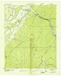 1935 Oswald Bald1935 Print · USGSThe Hiwassee River valley in the mid-1930s shows a landscape of mountain ridges and early Tennessee Valley Authority infrastructure. Trace family history at Taylor Sch and Benton Springs, or locate old industrial sites like Harrison Mill.
 - 1937 Map of Oswald Dome, 1954 Print
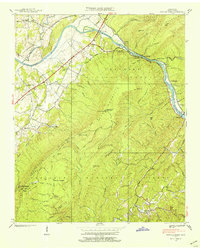 1937 Oswald Dome1954 Print · USGSPolk County in the late 1930s was a rugged river-and-rail corridor centered on the Hiwassee River and the Louisville and Nashville tracks. Family historians can trace local roots through landmarks like the Campbellite Cemetery, Antioch Church, and the river crossing at Reliance.
 - 1938 Map of Oswald Dome
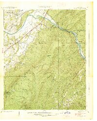 1938 Oswald Dome1938 Print · USGSPolk County in the late 1930s shows a mountain landscape where the Hiwassee River meets the Louisville and Nashville RR. Genealogists and researchers can trace family landmarks like Harrison Mill, Paris Cem, and the community at Reliance.
End of results
Showing maps 1-3 of 3
Top cities near Archville
- Etowah historical maps
- McCaysville historical maps
- Benton historical maps
- Tellico Plains historical maps
- Charleston historical maps
- Calhoun historical maps
See more
Frequently asked questions
- What are the different types of historical maps available for Archville?
- What is the oldest map of Archville?
- Where can I purchase historical maps of Archville for my home or office?
- Where can I download high-res historical maps of Archville?
- Are there historical topographic maps available for Archville?
- Is there historical aerial imagery available for Archville?
- Where are historical maps of Archville sourced from?