1940s Maps of Oldfort, Tennessee
Explore 2 historic maps of Oldfort from the 1940s. These maps offer a rare glimpse into what life looked like during the 1940s — showing old roads, neighborhoods, homes, and landmarks that have changed or disappeared over time.
Whether you're researching your family's past, planning a metal detecting trip, or studying how Oldfort's landscape evolved across the 1940s, these high-resolution maps are a powerful tool for exploring the history of this region.
- Focus on a specific era: All maps on this page are from the 1940s, giving you a focused view of this time period.
- See what’s changed: Compare century-old streets, trails, and buildings to today's modern landscape using overlays and satellite layers.
- Research with precision: Use these maps for genealogy, historical research, land use analysis, or educational projects.
- View, download, or print: Maps are fully viewable online in high resolution, and can be downloaded or printed for your own records.
Start exploring Oldfort's history through authentic maps from the 1940s. This is your window into the past.
Oldfort, TN maps
(2)- 1942 Map of Parksville, 1960 Print
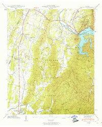 1942 Parksville1960 Print · USGSPolk County at the start of the 1940s shows the impact of hydropower and rail on the Appalachian landscape. Genealogists and historians can trace family locations through Oldfort and Conasauga, or locate rural landmarks like Horns Creek School and Antioch Church.2 unique versions available
 - 1943 Map of Parksville, 1946 Print
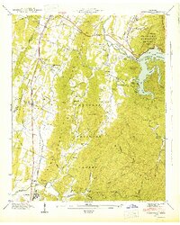 1943 Parksville1946 Print · USGSPolk County enters the mid-1940s as a landscape of forested ridges and harnessed river power. Local historians can trace the early footprint of Lake Ocoee and locate rural landmarks like Horns Creek Sch and the Hillard-Ladd Cem.
End of results
Showing maps 1-2 of 2
Top cities near Oldfort
- Cleveland historical maps
- Varnell historical maps
- Benton historical maps
- Charleston historical maps
- Cohutta historical maps
- Calhoun historical maps
Frequently asked questions
- What are the different types of historical maps available for Oldfort?
- What is the oldest map of Oldfort?
- Where can I purchase historical maps of Oldfort for my home or office?
- Where can I download high-res historical maps of Oldfort?
- Are there historical topographic maps available for Oldfort?
- Is there historical aerial imagery available for Oldfort?
- Where are historical maps of Oldfort sourced from?