1950s Maps of Monterey, Tennessee
Explore 7 historic maps of Monterey from the 1950s. These maps offer a rare glimpse into what life looked like during the 1950s — showing old roads, neighborhoods, homes, and landmarks that have changed or disappeared over time.
Whether you're researching your family's past, planning a metal detecting trip, or studying how Monterey's landscape evolved across the 1950s, these high-resolution maps are a powerful tool for exploring the history of this region.
- Focus on a specific era: All maps on this page are from the 1950s, giving you a focused view of this time period.
- See what’s changed: Compare century-old streets, trails, and buildings to today's modern landscape using overlays and satellite layers.
- Research with precision: Use these maps for genealogy, historical research, land use analysis, or educational projects.
- View, download, or print: Maps are fully viewable online in high resolution, and can be downloaded or printed for your own records.
Start exploring Monterey's history through authentic maps from the 1950s. This is your window into the past.
Monterey, TN maps
(7)- 1950 Map of Obey City
 1950 Obey City1950 Print · USGSOverton County’s rugged plateau terrain is captured here in the post-war era as the Tennessee Central railroad served the mountain communities. Genealogists can trace family roots at Obey City, Hanging Limb, and numerous rural landmarks like Buckner Chapel or the Shaver Cem.
 - 1950 Map of Campbell Junction
 1950 Campbell Junction1950 Print · USGSThe Cumberland Plateau in the mid-century is captured here as the Tennessee Central railroad snakes through the divide between Putnam and Cumberland counties. Family researchers can trace local roots through Welch Cem, Rains Cem, and settlements like Campbell Junction and The Cowpens.2 unique versions available
 - 1955 Map of Monterey Lake, 1956 Print
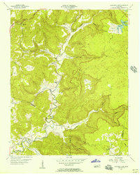
 1955 Monterey Lake1956 Print · USGSThe Putnam County plateau comes into focus in the mid-fifties, centered on the railroad town of Monterey. Researchers can trace the winding Tennessee Central tracks through a landscape of family-named landmarks like Stamps Cem, Lee Sch, and Bee Rock.
 - 1955 Map of Monterey, 1973 Print
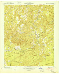
 1955 Monterey1973 Print · USGSThe Cumberland Plateau in the mid-1950s is centered on the railroad town of Monterey and the surrounding high ridges. Local historians can trace family roots through numerous landmarks like Shady Grove Sch, Welch Memorial Cem, and the Tennessee Central Railroad corridor.3 unique versions available
 - 1956 Map of Monterey Lake, 1957 Print
 1956 Monterey Lake1957 Print · USGSThe Cumberland Plateau in the mid-1950s is defined by its deep coves and the winding Calfkiller River. Researchers can trace rural family life through landmarks like Big Spring Sch, Johnson Ch, and the Crouse Cem.3 unique versions available
 - 1956 Map of Corbin, 1966 Print
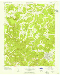
 1956 Corbin1966 Print · USGSThe Kentucky and Tennessee borderlands are captured here in the mid-fifties, showing the region's shift toward modern interstate travel and reservoir development. Genealogists and historians can trace old community lines near Albany and Monticello or locate early rail junctions along the Southern and Tennessee Central lines.3 unique versions available
 - 1958 Map of Corbin
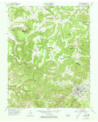
 1958 Corbin1958 Print · USGSThe Upper Cumberland borderlands appear in the late 1950s as massive reservoirs and early atomic-era growth reshape the region. Trace family roots and vanished landmarks near Lake Cumberland, Oak Ridge, and the Cumberland National Forest.
End of results
Showing maps 1-7 of 7
Top cities near Monterey
- Cookeville historical maps
- Crossville historical maps
- Sparta historical maps
- Livingston historical maps
- Algood historical maps
- Pleasant Hill historical maps
Top neighborhoods of Monterey
Frequently asked questions
- What are the different types of historical maps available for Monterey?
- What is the oldest map of Monterey?
- Where can I purchase historical maps of Monterey for my home or office?
- Where can I download high-res historical maps of Monterey?
- Are there historical topographic maps available for Monterey?
- Is there historical aerial imagery available for Monterey?
- Where are historical maps of Monterey sourced from?