1930s Maps of Dayton, Tennessee
Explore 4 historic maps of Dayton from the 1930s. These maps offer a rare glimpse into what life looked like during the 1930s — showing old roads, neighborhoods, homes, and landmarks that have changed or disappeared over time.
Whether you're researching your family's past, planning a metal detecting trip, or studying how Dayton's landscape evolved across the 1930s, these high-resolution maps are a powerful tool for exploring the history of this region.
- Focus on a specific era: All maps on this page are from the 1930s, giving you a focused view of this time period.
- See what’s changed: Compare century-old streets, trails, and buildings to today's modern landscape using overlays and satellite layers.
- Research with precision: Use these maps for genealogy, historical research, land use analysis, or educational projects.
- View, download, or print: Maps are fully viewable online in high resolution, and can be downloaded or printed for your own records.
Start exploring Dayton's history through authentic maps from the 1930s. This is your window into the past.
Dayton, TN maps
(4)- 1935 Map of Morgan Springs
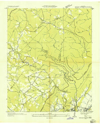 1935 Morgan Springs1935 Print · USGSWalden Ridge and the Tennessee valley transition are documented here in the mid-1930s, showing a landscape of small schools and plateau settlements. Researchers can trace the Cumberland Escarpment to find Henderson Mill, Morgan Springs, and the Incline railroad.
 - 1935 Map of Evensville
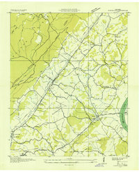 1935 Evensville1935 Print · USGSRhea County is captured in the mid-1930s as the Tennessee Valley Authority begins modernizing the region's infrastructure. Researchers can locate numerous rural landmarks including Henry Ferry, Evens Cem, and old schoolhouses like Locke Sch and Oak Hill Sch.
 - 1935 Map of Big Spring
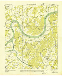 1935 Big Spring1935 Print · USGSThe Tennessee and Hiwassee rivers define the landscape in the mid-thirties, when ferries were the primary links between Meigs and Rhea counties. Genealogists can trace family roots through labels for Big Spring, Salem Ch, and the Garrison Cem.
 - 1935 Map of Graysville
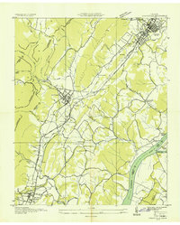 1935 Graysville1935 Print · USGSRhea and Hamilton counties are shown in detail during the mid-1930s, caught between the ridge-and-valley terrain and the river. Genealogists can locate family landmarks like Welch Cem, trace the historic Blythe Ferry, or find CCC Camp No 3470.
End of results
Showing maps 1-4 of 4
Top cities near Dayton
- Soddy-Daisy historical maps
- Spring City historical maps
- Pikeville historical maps
- Decatur historical maps
- Graysville historical maps
Top neighborhoods of Dayton
- North Dayton historical maps
- Taylor Hill historical maps
- Sentinel Heights historical maps
- Edgewater historical maps
- Piney Acres historical maps
- Mountain View historical maps
See more
Frequently asked questions
- What are the different types of historical maps available for Dayton?
- What is the oldest map of Dayton?
- Where can I purchase historical maps of Dayton for my home or office?
- Where can I download high-res historical maps of Dayton?
- Are there historical topographic maps available for Dayton?
- Is there historical aerial imagery available for Dayton?
- Where are historical maps of Dayton sourced from?