1940s Maps of Dayton, Tennessee
Explore 5 historic maps of Dayton from the 1940s. These maps offer a rare glimpse into what life looked like during the 1940s — showing old roads, neighborhoods, homes, and landmarks that have changed or disappeared over time.
Whether you're researching your family's past, planning a metal detecting trip, or studying how Dayton's landscape evolved across the 1940s, these high-resolution maps are a powerful tool for exploring the history of this region.
- Focus on a specific era: All maps on this page are from the 1940s, giving you a focused view of this time period.
- See what’s changed: Compare century-old streets, trails, and buildings to today's modern landscape using overlays and satellite layers.
- Research with precision: Use these maps for genealogy, historical research, land use analysis, or educational projects.
- View, download, or print: Maps are fully viewable online in high resolution, and can be downloaded or printed for your own records.
Start exploring Dayton's history through authentic maps from the 1940s. This is your window into the past.
Dayton, TN maps
(5)- 1942 Map of Big Spring
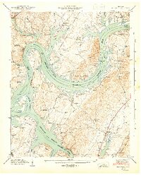
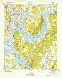 1942 Big Spring1942 Print · USGSThe Tennessee and Hiwassee Rivers meet in the early 1940s, revealing a landscape of reservoir development and deep-rooted farm communities. Genealogists can locate Big Spring and family sites like Shaver Cem, while historians can trace the Cotton Port Ferry.
 - 1942 Map of Evensville, 1946 Print
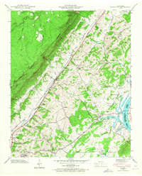 1942 Evensville1946 Print · USGSRhea County is captured here in the early 1940s as the Tennessee Valley Authority projects reshaped the river landscape. Genealogists can trace family names through dozens of landmarks, including Washington Ferry, Smyrna Ch, and the Montgomery Cem.3 unique versions available
 - 1942 Map of Graysville, 1956 Print
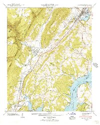 1942 Graysville1956 Print · USGSRhea County and the Tennessee River valley appear here in the early 1940s as newly formed reservoirs altered the landscape. Researchers can trace the historic Blythe Ferry crossing and find long-established local sites like New Providence Sch and the Old Browder Cem.2 unique versions available
 - 1943 Map of Graysville
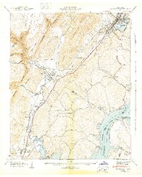 1943 Graysville1943 Print · USGSEast Tennessee at the dawn of the 1940s reveals a landscape of ridge-and-valley settlements tied to the river and rail. Genealogists can trace family names through the Graysville Cem, New Providence Sch, and numerous churches like Garrison Ch.2 unique versions available
 - 1943 Map of Big Spring, 1946 Print
 1943 Big Spring1946 Print · USGSThe Tennessee River valley in the early 1940s reveals a landscape reshaped by the newly formed Chickamauga Reservoir. Genealogists and local historians can trace family land near Big Spring, the Cotton Port Ferry, and numerous country churches like Burkett Chapel.2 unique versions available
End of results
Showing maps 1-5 of 5
Top cities near Dayton
- Soddy-Daisy historical maps
- Spring City historical maps
- Pikeville historical maps
- Decatur historical maps
- Graysville historical maps
Top neighborhoods of Dayton
- North Dayton historical maps
- Taylor Hill historical maps
- Sentinel Heights historical maps
- Edgewater historical maps
- Piney Acres historical maps
- Mountain View historical maps
See more
Frequently asked questions
- What are the different types of historical maps available for Dayton?
- What is the oldest map of Dayton?
- Where can I purchase historical maps of Dayton for my home or office?
- Where can I download high-res historical maps of Dayton?
- Are there historical topographic maps available for Dayton?
- Is there historical aerial imagery available for Dayton?
- Where are historical maps of Dayton sourced from?