1900s (20th Century) Maps of Eagleville, Tennessee
Explore 11 historic maps of Eagleville from the 1900s (20th Century). These maps offer a rare glimpse into what life looked like during the 1900s — showing old roads, neighborhoods, homes, and landmarks that have changed or disappeared over time.
Whether you're researching your family's past, planning a metal detecting trip, or studying how Eagleville's landscape evolved across the 1900s, these high-resolution maps are a powerful tool for exploring the history of this region.
- Focus on a specific era: All maps on this page are from the 1900s, giving you a focused view of this time period.
- See what’s changed: Compare century-old streets, trails, and buildings to today's modern landscape using overlays and satellite layers.
- Research with precision: Use these maps for genealogy, historical research, land use analysis, or educational projects.
- View, download, or print: Maps are fully viewable online in high resolution, and can be downloaded or printed for your own records.
Start exploring Eagleville's history through authentic maps from the 1900s. This is your window into the past.
Eagleville, TN maps
(11)- 1936 Map of Chapel Hill
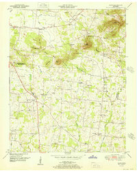
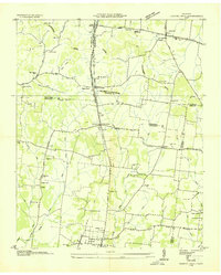 1936 Chapel Hill1936 Print · USGSMiddle Tennessee’s rural landscape is captured here in the mid-1930s as the regional electrical grid was expanding. Researchers can locate vanished landmarks like the Holtland PO, trace family roots at LESTER CEM, or find the old Edwards Grove Ch.
 - 1936 Map of Rover
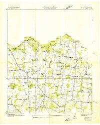 1936 Rover1936 Print · USGSMiddle Tennessee farmland at the Rutherford and Bedford county line is meticulously captured in the mid-thirties. Family historians can trace dozens of burial sites and community centers like Rover, Kingdom Ch, and the Vernon Corner Sch.
 - 1942 Map of Lebanon, 1944 Print
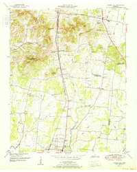
 1942 Lebanon1944 Print · USGSMiddle Tennessee at the start of the war years reveals a landscape of historic homesteads and burgeoning military infrastructure. Genealogists and historians can trace family locations near The Hermitage, follow the Tennessee Central rail lines, or locate the newly established Smyrna Air Base.
 - 1944 Map of Shelbyville
 1944 Shelbyville1944 Print · USGSMid-century Middle Tennessee is captured here during the wartime mobilization of the 1940s. Genealogists and researchers can trace family lands near Bugscuffle, Shelbyville Mills, and the expansive Camp Forrest Military Res.
 - 1949 Map of Rover, 1966 Print
 1949 Rover1966 Print · USGSIn the late 1940s, the rural border between Rutherford and Bedford counties remained a landscape of family farms and country crossroads. Researchers can trace ancestral locations like Puckett Store, the Vernon Corner School, and family-named landmarks like Putman Well.3 unique versions available
 - 1949 Map of Chapel Hill, 1966 Print
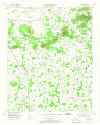
 1949 Chapel Hill1966 Print · USGSMid-century Middle Tennessee comes to life here as the rail-and-road network connects rural Marshall and Rutherford counties. Genealogists can trace family landmarks across dozens of sites like Riggs Chapel, Holtland (PO), and the Marrs Hill Cem.2 unique versions available
 - 1951 Map of Rover
 1951 Rover1951 Print · USGSBedford and Rutherford Counties were still largely defined by dispersed farmsteads and family-named ridges in the years following World War II. Genealogists can trace dozens of rural burial sites and landmarks like Puckett Store, Kingdom Ch, and the Woodson Cem.
 - 1951 Map of Chapel Hill
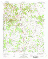
 1951 Chapel Hill1951 Print · USGSMid-century Middle Tennessee is captured here as a landscape of family farms and railroad hamlets along the Louisville and Nashville line. Genealogists can trace hundreds of family names through sites like Riggs Crossroads, Edwards Grove Ch, and Marrs Hill Cem.
 - 1956 Map of Columbia, 1960 Print
 1956 Columbia1960 Print · USGSMiddle Tennessee in the mid-fifties presents a landscape of established river towns and critical rail hubs before the arrival of the modern interstate system. Researchers can trace the routes of the Louisville and Nashville railroad or locate historic landmarks like Stones River National Military Park and the Tennessee National Wildlife Refuge.6 unique versions available
 - 1957 Map of College Grove, 1958 Print
 1957 College Grove1958 Print · USGSWilliamson County was a landscape of rail-connected farming hamlets and country churches during the late fifties. You can trace the Louisville and Nashville Railroad through College Grove or locate the historic Newton Cannon Cem and Kirkland Sch.4 unique versions available
 - 1985 Map of Murfreesboro, 1986 Print
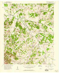
 1985 Murfreesboro1986 Print · USGSMiddle Tennessee in the mid-1980s shows a landscape of growing towns and deep-rooted rural outposts. Local researchers can trace old family lines near Bell Buckle, locate landmarks like Donnel Chapel, or explore the grounds of Henry Horton State Park and Hoovers Gap.
End of results
Showing maps 1-11 of 11
Top cities near Eagleville
- Murfreesboro historical maps
- Franklin historical maps
- Smyrna historical maps
- Brentwood historical maps
- Spring Hill historical maps
- La Vergne historical maps
See more
Frequently asked questions
- What are the different types of historical maps available for Eagleville?
- What is the oldest map of Eagleville?
- Where can I purchase historical maps of Eagleville for my home or office?
- Where can I download high-res historical maps of Eagleville?
- Are there historical topographic maps available for Eagleville?
- Is there historical aerial imagery available for Eagleville?
- Where are historical maps of Eagleville sourced from?