1900s (20th Century) Maps of Plainview, Tennessee
Explore 6 historic maps of Plainview from the 1900s (20th Century). These maps offer a rare glimpse into what life looked like during the 1900s — showing old roads, neighborhoods, homes, and landmarks that have changed or disappeared over time.
Whether you're researching your family's past, planning a metal detecting trip, or studying how Plainview's landscape evolved across the 1900s, these high-resolution maps are a powerful tool for exploring the history of this region.
- Focus on a specific era: All maps on this page are from the 1900s, giving you a focused view of this time period.
- See what’s changed: Compare century-old streets, trails, and buildings to today's modern landscape using overlays and satellite layers.
- Research with precision: Use these maps for genealogy, historical research, land use analysis, or educational projects.
- View, download, or print: Maps are fully viewable online in high resolution, and can be downloaded or printed for your own records.
Start exploring Plainview's history through authentic maps from the 1900s. This is your window into the past.
Plainview, TN maps
(6)- 1936 Map of Webbs Jungle
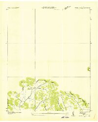 1936 Webbs Jungle1936 Print · USGSRutherford and Bedford Counties are captured in the mid-1930s, showing a rural landscape defined by the Tennessee Basin Divide. Genealogists and local historians can trace family locations near Webbs Jungle, the Beechwood Ch, and along Wartrace Creek.
 - 1944 Map of Shelbyville
 1944 Shelbyville1944 Print · USGSMid-century Middle Tennessee is captured here during the wartime mobilization of the 1940s. Genealogists and researchers can trace family lands near Bugscuffle, Shelbyville Mills, and the expansive Camp Forrest Military Res.
 - 1949 Map of Webbs Jungle, 1975 Print
 1949 Webbs Jungle1975 Print · USGSRutherford and Bedford Counties appear in the late 1940s as a landscape of river-bottom farms and ridge-top hollows. Genealogists can locate family landmarks such as the Preter Cem, Buchanan School, and the Millersburg Church.3 unique versions available
 - 1951 Map of Webbs Jungle
 1951 Webbs Jungle1951 Print · USGSRutherford and Bedford Counties are shown here in the early 1950s, centered on the strategic crossing at Hoovers Gap. Family researchers can locate many rural landmarks including Buchanan School, the Millersburg Cem, and New Hope Church.2 unique versions available
 - 1956 Map of Columbia, 1960 Print
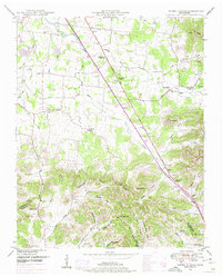
 1956 Columbia1960 Print · USGSMiddle Tennessee in the mid-fifties presents a landscape of established river towns and critical rail hubs before the arrival of the modern interstate system. Researchers can trace the routes of the Louisville and Nashville railroad or locate historic landmarks like Stones River National Military Park and the Tennessee National Wildlife Refuge.6 unique versions available
 - 1985 Map of Murfreesboro, 1986 Print
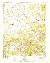
 1985 Murfreesboro1986 Print · USGSMiddle Tennessee in the mid-1980s shows a landscape of growing towns and deep-rooted rural outposts. Local researchers can trace old family lines near Bell Buckle, locate landmarks like Donnel Chapel, or explore the grounds of Henry Horton State Park and Hoovers Gap.
End of results
Showing maps 1-6 of 6
Top cities near Plainview
- Murfreesboro historical maps
- Smyrna historical maps
- Shelbyville historical maps
- Manchester historical maps
- Wartrace historical maps
- Bell Buckle historical maps
Frequently asked questions
- What are the different types of historical maps available for Plainview?
- What is the oldest map of Plainview?
- Where can I purchase historical maps of Plainview for my home or office?
- Where can I download high-res historical maps of Plainview?
- Are there historical topographic maps available for Plainview?
- Is there historical aerial imagery available for Plainview?
- Where are historical maps of Plainview sourced from?