1990s Maps of Walterhill, Tennessee
Explore 2 historic maps of Walterhill from the 1990s. These maps offer a rare glimpse into what life looked like during the 1990s — showing old roads, neighborhoods, homes, and landmarks that have changed or disappeared over time.
Whether you're researching your family's past, planning a metal detecting trip, or studying how Walterhill's landscape evolved across the 1990s, these high-resolution maps are a powerful tool for exploring the history of this region.
- Focus on a specific era: All maps on this page are from the 1990s, giving you a focused view of this time period.
- See what’s changed: Compare century-old streets, trails, and buildings to today's modern landscape using overlays and satellite layers.
- Research with precision: Use these maps for genealogy, historical research, land use analysis, or educational projects.
- View, download, or print: Maps are fully viewable online in high resolution, and can be downloaded or printed for your own records.
Start exploring Walterhill's history through authentic maps from the 1990s. This is your window into the past.
Walterhill, TN maps
(2)- 1994 Map of Vine, 1997 Print
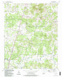 1994 Vine1997 Print · USGSThe Wilson and Rutherford county borderlands appear in the mid-nineties as a landscape of dense state forests and scattered rural hamlets. Researchers can trace family landmarks like Jacobs Hill Ch, find the old crossing at Bairds Mill, or explore Hermit Cave.
 - 1998 Map of Walterhill, 1999 Print
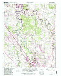 1998 Walterhill1999 Print · USGSRutherford County in the late nineties shows a landscape where growing Murfreesboro meets the winding forks of the Stones River. Genealogists can locate family landmarks like Waller Cem and Hickory Grove Ch, or trace the grounds of Stones River National Battlefield.
End of results
Showing maps 1-2 of 2
Top cities near Walterhill
- Nashville historical maps
- Murfreesboro historical maps
- Smyrna historical maps
- La Vergne historical maps
- Lebanon historical maps
- Mount Juliet historical maps
See more
Top neighborhoods of Walterhill
- Estes Acres historical maps
- Walter Hill Estates historical maps
- Bethel historical maps
- Silver Hill historical maps
- Juniper Acres historical maps
- Hillwood Estates historical maps
See more
Frequently asked questions
- What are the different types of historical maps available for Walterhill?
- What is the oldest map of Walterhill?
- Where can I purchase historical maps of Walterhill for my home or office?
- Where can I download high-res historical maps of Walterhill?
- Are there historical topographic maps available for Walterhill?
- Is there historical aerial imagery available for Walterhill?
- Where are historical maps of Walterhill sourced from?