1930s Maps of Gatlinburg, Tennessee
Explore 4 historic maps of Gatlinburg from the 1930s. These maps offer a rare glimpse into what life looked like during the 1930s — showing old roads, neighborhoods, homes, and landmarks that have changed or disappeared over time.
Whether you're researching your family's past, planning a metal detecting trip, or studying how Gatlinburg's landscape evolved across the 1930s, these high-resolution maps are a powerful tool for exploring the history of this region.
- Focus on a specific era: All maps on this page are from the 1930s, giving you a focused view of this time period.
- See what’s changed: Compare century-old streets, trails, and buildings to today's modern landscape using overlays and satellite layers.
- Research with precision: Use these maps for genealogy, historical research, land use analysis, or educational projects.
- View, download, or print: Maps are fully viewable online in high resolution, and can be downloaded or printed for your own records.
Start exploring Gatlinburg's history through authentic maps from the 1930s. This is your window into the past.
Gatlinburg, TN maps
(4)- 1935 Map of English Mountain
 1935 English Mountain1935 Print · USGSSevier County and the foothills of the Smokies are seen here during the mid-thirties as the national park was taking shape. Genealogists can trace family roots through scores of rural institutions like Smoky Mtn Academy, Pittman Center, and the Crockettville Sch.
 - 1935 Map of Richardson Cove
 1935 Richardson Cove1935 Print · USGSSevier County communities appear here in the mid-1930s, nestled between the ridgelines of the Great Smokies. Genealogists can trace family landmarks and schools including Smoky Mtn Academy, Richardson Cove, and Oldham.
 - 1936 Map of Gatlinburg
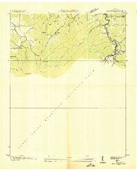 1936 Gatlinburg1936 Print · USGSGatlinburg and the northern Smokies appear here during the mid-1930s as the national park was being established. Genealogists can trace family homesteads near Starkeytown or locate landmarks like Husky Grove Ch and the Covemont Sch.
 - 1936 Map of Cartertown
 1936 Cartertown1936 Print · USGSSevier County communities sit along the edge of the newly established national park in the mid-1930s. Researchers can locate family landmarks like the Mc Carter Cem and Proffitt Cem or trace early school sites including Roaring Fork Sch.2 unique versions available
End of results
Showing maps 1-4 of 4
Top cities near Gatlinburg
- Knoxville historical maps
- Sevierville historical maps
- Newport historical maps
- Pigeon Forge historical maps
- Pittman Center historical maps
Top neighborhoods of Gatlinburg
Frequently asked questions
- What are the different types of historical maps available for Gatlinburg?
- What is the oldest map of Gatlinburg?
- Where can I purchase historical maps of Gatlinburg for my home or office?
- Where can I download high-res historical maps of Gatlinburg?
- Are there historical topographic maps available for Gatlinburg?
- Is there historical aerial imagery available for Gatlinburg?
- Where are historical maps of Gatlinburg sourced from?