1960s Maps of Goodman, Memphis
Explore 2 historic maps of Goodman from the 1960s. These maps offer a rare glimpse into what life looked like during the 1960s — showing old roads, neighborhoods, homes, and landmarks that have changed or disappeared over time.
Whether you're researching your family's past, planning a metal detecting trip, or studying how Goodman's landscape evolved across the 1960s, these high-resolution maps are a powerful tool for exploring the history of this region.
- Focus on a specific era: All maps on this page are from the 1960s, giving you a focused view of this time period.
- See what’s changed: Compare century-old streets, trails, and buildings to today's modern landscape using overlays and satellite layers.
- Research with precision: Use these maps for genealogy, historical research, land use analysis, or educational projects.
- View, download, or print: Maps are fully viewable online in high resolution, and can be downloaded or printed for your own records.
Start exploring Goodman's history through authentic maps from the 1960s. This is your window into the past.
Goodman, Memphis maps
(2)- 1960 Map of Memphis, 1963 Print
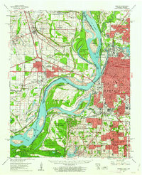 1960 Memphis1963 Print · USGSGreater Memphis and its Arkansas neighbors are shown at a peak of industrial and suburban growth. Trace family history through old landmarks like Locella Ch, the Marion Flying Service, and established cemeteries such as Forest Hill Cem.2 unique versions available
 - 1965 Map of Southwest Memphis, 1967 Print
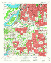 1965 Southwest Memphis1967 Print · USGSMid-century South Memphis and Whitehaven are shown here during a period of significant urban growth and industrial activity. Researchers can trace the footprints of Defense Depot Memphis, the historic grounds of Elmwood Cemetery, and local landmarks like LeMoyne College.5 unique versions available
End of results
Showing maps 1-2 of 2
Top cities near Goodman
- Memphis historical maps
- Bartlett historical maps
- Southaven historical maps
- Olive Branch historical maps
- Horn Lake historical maps
- West Memphis historical maps
See more
Frequently asked questions
- What are the different types of historical maps available for Goodman?
- What is the oldest map of Goodman?
- Where can I purchase historical maps of Goodman for my home or office?
- Where can I download high-res historical maps of Goodman?
- Are there historical topographic maps available for Goodman?
- Is there historical aerial imagery available for Goodman?
- Where are historical maps of Goodman sourced from?