1960s Maps of Camp Tom Howard, Tennessee
Explore 2 historic maps of Camp Tom Howard from the 1960s. These maps offer a rare glimpse into what life looked like during the 1960s — showing old roads, neighborhoods, homes, and landmarks that have changed or disappeared over time.
Whether you're researching your family's past, planning a metal detecting trip, or studying how Camp Tom Howard's landscape evolved across the 1960s, these high-resolution maps are a powerful tool for exploring the history of this region.
- Focus on a specific era: All maps on this page are from the 1960s, giving you a focused view of this time period.
- See what’s changed: Compare century-old streets, trails, and buildings to today's modern landscape using overlays and satellite layers.
- Research with precision: Use these maps for genealogy, historical research, land use analysis, or educational projects.
- View, download, or print: Maps are fully viewable online in high resolution, and can be downloaded or printed for your own records.
Start exploring Camp Tom Howard's history through authentic maps from the 1960s. This is your window into the past.
Camp Tom Howard, TN maps
(2)- 1960 Map of Shady Valley, 1962 Print
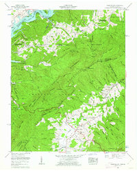 1960 Shady Valley1962 Print · USGSShady Valley and the Iron Mountains are captured here in the early sixties, showing a high Appalachian basin defined by family farms and forest management. Researchers can trace family roots at Potter Cem and Crosswhite Cem or locate the old Shady Valley Sch.4 unique versions available
 - 1962 Map of Winston-Salem
 1962 Winston-Salem1962 Print · USGSThe North Carolina Piedmont meets the Virginia highlands in the early sixties, showing the rail corridors and mountain gaps of the southern Appalachians. Researchers can trace the Blue Ridge Parkway or locate family sites near Winston-Salem, Mount Airy, and Hanging Rock Mountain.
End of results
Showing maps 1-2 of 2
Top cities near Camp Tom Howard
- Bristol historical maps
- Bristol historical maps
- Elizabethton historical maps
- Abingdon historical maps
- Mountain City historical maps
- Damascus historical maps
See more
Frequently asked questions
- What are the different types of historical maps available for Camp Tom Howard?
- What is the oldest map of Camp Tom Howard?
- Where can I purchase historical maps of Camp Tom Howard for my home or office?
- Where can I download high-res historical maps of Camp Tom Howard?
- Are there historical topographic maps available for Camp Tom Howard?
- Is there historical aerial imagery available for Camp Tom Howard?
- Where are historical maps of Camp Tom Howard sourced from?