1960s Maps of Hendersonville, Tennessee
Explore 3 historic maps of Hendersonville from the 1960s. These maps offer a rare glimpse into what life looked like during the 1960s — showing old roads, neighborhoods, homes, and landmarks that have changed or disappeared over time.
Whether you're researching your family's past, planning a metal detecting trip, or studying how Hendersonville's landscape evolved across the 1960s, these high-resolution maps are a powerful tool for exploring the history of this region.
- Focus on a specific era: All maps on this page are from the 1960s, giving you a focused view of this time period.
- See what’s changed: Compare century-old streets, trails, and buildings to today's modern landscape using overlays and satellite layers.
- Research with precision: Use these maps for genealogy, historical research, land use analysis, or educational projects.
- View, download, or print: Maps are fully viewable online in high resolution, and can be downloaded or printed for your own records.
Start exploring Hendersonville's history through authentic maps from the 1960s. This is your window into the past.
Hendersonville, TN maps
(3)- 1968 Map of Hermitage, 1970 Print
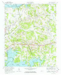 1968 Hermitage1970 Print · USGSThe Hermitage area in the late sixties displays a landscape transitioning from rural estates to suburban reaches between two major Tennessee reservoirs. Trace local history through The Hermitage Tomb, Mount Juliet High Sch, and family-named landmarks like Bakers Grove Ch.3 unique versions available
 - 1968 Map of Goodlettsville, 1971 Print
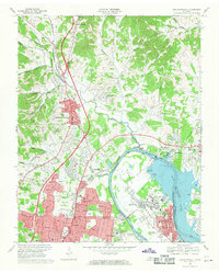 1968 Goodlettsville1971 Print · USGSThe northern suburbs of Nashville were rapidly evolving in the late sixties as the Cumberland River landscape was reshaped. Researchers can find many family landmarks, from Lutons Chapel and Old Center Ch to the rail siding at Amqui.4 unique versions available
 - 1968 Map of Hendersonville, 1971 Print
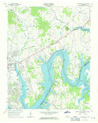 1968 Hendersonville1971 Print · USGSThe Hendersonville area is captured here during its late-sixties growth as Old Hickory Lake reshaped the local topography. Genealogists can trace family roots through landmarks like St Johns Ch, Peytona, and the rural schools and churches of Shackle Island.2 unique versions available
End of results
Showing maps 1-3 of 3
Top cities near Hendersonville
- Nashville historical maps
- La Vergne historical maps
- Gallatin historical maps
- Lebanon historical maps
- North Nashville historical maps
- Goodlettsville historical maps
See more
Top neighborhoods of Hendersonville
- Walnut Hills Estates historical maps
- Avondale historical maps
- Bluegrass Meadows historical maps
- Nokes Heights historical maps
- Point O'View historical maps
- Colonial Acres historical maps
See more
Frequently asked questions
- What are the different types of historical maps available for Hendersonville?
- What is the oldest map of Hendersonville?
- Where can I purchase historical maps of Hendersonville for my home or office?
- Where can I download high-res historical maps of Hendersonville?
- Are there historical topographic maps available for Hendersonville?
- Is there historical aerial imagery available for Hendersonville?
- Where are historical maps of Hendersonville sourced from?