1940s Maps of Van Buren County, Tennessee
Explore 6 historic maps of Van Buren County from the 1940s. These maps offer a rare glimpse into what life looked like during the 1940s — showing old roads, neighborhoods, homes, and landmarks that have changed or disappeared over time.
Whether you're researching your family's past, planning a metal detecting trip, or studying how Van Buren County's landscape evolved across the 1940s, these high-resolution maps are a powerful tool for exploring the history of this region.
- Focus on a specific era: All maps on this page are from the 1940s, giving you a focused view of this time period.
- See what’s changed: Compare century-old streets, trails, and buildings to today's modern landscape using overlays and satellite layers.
- Research with precision: Use these maps for genealogy, historical research, land use analysis, or educational projects.
- View, download, or print: Maps are fully viewable online in high resolution, and can be downloaded or printed for your own records.
Start exploring Van Buren County's history through authentic maps from the 1940s. This is your window into the past.
Van Buren County, TN maps
(6)- 1943 Map of Cookeville
 1943 Cookeville1943 Print · USGSMiddle Tennessee during the early 1940s reveals a landscape defined by the Tennessee Central Railroad and the ascent to the Cumberland Plateau. Trace local heritage through rural settlements like Silver Point and Bloomington Springs or the river crossing at Hodge Ferry.
 - 1944 Map of Cookeville
 1944 Cookeville1944 Print · USGSUpper Tennessee during the war years shows a landscape shaped by deep river gorges and the rising Cumberland Plateau. Researchers can trace old mountain settlements like Bon Air or locate river landmarks such as Hodge Ferry and Burgess Falls Dam.
 - 1946 Map of Smartt Mountain, 1962 Print
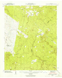 1946 Smartt Mountain1962 Print · USGSHigh atop the Cumberland Plateau in the mid-1940s, this area spans the intersection of three Tennessee counties during a period of remote mountain settlement. Genealogists can locate family landmarks like Jordan Rock House, Bellview Church, and the Hitchcox Cem.4 unique versions available
 - 1946 Map of Brockdell, 1963 Print
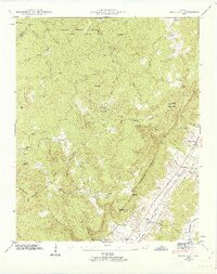 1946 Brockdell1963 Print · USGSBledsoe County at the end of the Second World War shows a landscape defined by the rugged descent from the Cumberland Plateau. Genealogists and researchers can locate family landmarks like Brockdell Ch, Rainey Cem, and the old rail stops at Lees Station and College Station.4 unique versions available
 - 1947 Map of Brockdell
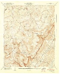 1947 Brockdell1947 Print · USGSBledsoe County is shown just after the war when the plateau and valley floor were distinct worlds connected by steep gulfs. Genealogists can trace family names at Rainey Cem or locate former schoolhouses like Rebecca Sch and Lusk Sch.2 unique versions available
 - 1947 Map of Smartt Mountain, 1948 Print
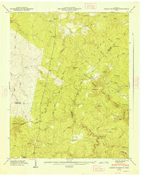 1947 Smartt Mountain1948 Print · USGSThe Cumberland Plateau of Van Buren and Bledsoe Counties is captured here in the mid-1940s, revealing a landscape of ridge-top churches and isolated valley cemeteries. Genealogists can trace family roots at Miller Cem, Bellview Ch, and the landmark Jordan Rock House.
End of results
Showing maps 1-6 of 6
Top cities of Van Buren County
Frequently asked questions
- What are the different types of historical maps available for Van Buren County?
- What is the oldest map of Van Buren County?
- Where can I purchase historical maps of Van Buren County for my home or office?
- Where can I download high-res historical maps of Van Buren County?
- Are there historical topographic maps available for Van Buren County?
- Is there historical aerial imagery available for Van Buren County?
- Where are historical maps of Van Buren County sourced from?